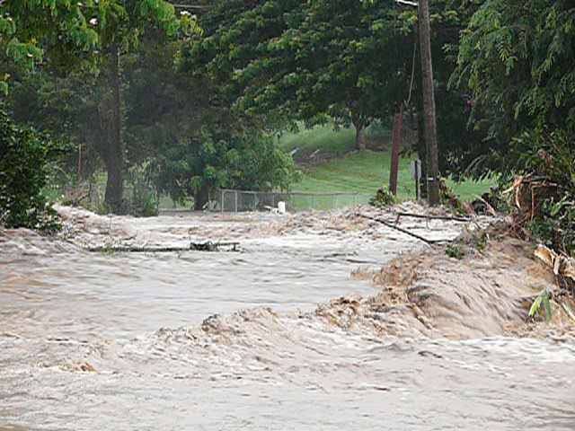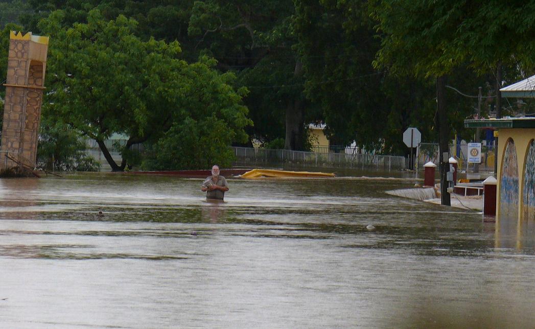
Public Works Commissioner Darryl Smalls called the situation on St. Croix critical.
“Especially on the West End,” he said.
Some areas received over six inches of rain since the rain began falling Wednesday morning, Smalls said.
Areas hit hard include sections of the Melvin Evans Highway in both directions, areas along Queen Mary Highway near Mutual Homes and the Patrick Sweeney Police Department headquarters, Ham’s Bluff, and Prosperity, Smalls said.
Smalls said that the flooding is so severe in some locations that drivers had to be rescued from their cars. He said that in one case, a police officer tried to rescue a driver who had been washed out of his car and was in a tree. The driver and the police officer both had to be rescued, Smalls said.
So far, there are no reports of mudslides on St. Croix, but Smalls said with the continued rain, that situation could change.
“We’re continuing to monitor the situation,” he said.
Police Commissioner Novelle Francis added several other areas to the list of roads impacted by the rain. They included East Airport Road and the road through Williams Delight.
St. Thomas and St. John haven’t had nearly the amount of rain seen on St. Croix. Sharon Coldren, president of the Coral Bay Community Council, said she received no reports of mudslides. The area was hit hard in the early October rains, and the hillsides remain in a precarious state.
V.I. Water and Power Authority Director Hugo Hodge Jr. reported no downed power lines anywhere across the territory.
“Knock on wood,” he said.
However, he urged people to be careful should they encounter any fallen lines.
He also said that so far, the power plants were up to the task.
Downtown Christiansted was definitely damp on Wednesday.

On the plus side, she said cisterns were overflowing, but on the minus side, the tourists weren’t happy. However, she said visitors were out and about between deluges.
“We’re going to get through it,” she said.
As for the rest of the week, meteorologist Luis Rosa at the National Weather Service in San Juan expects more heavy rain Wednesday night into early Thursday as a warm front heads north. He said Thursday should be drier.
“Just showers and high clouds, but you’re not going to see much in the way of sun,” he said.
On Friday, residents should look for a significant improvement in the weather.
However, the territory remains on a flash flood alert until Friday morning.
By Saturday, Rosa said significant swells will hit the coasts. They will remain until Sunday. He said that they could be as bad as the March 2008 high swells that caused coastal flooding on St. Thomas.
A press release from the University of the Virgin Islands indicated that all evening classes on the St. Croix campus are cancelled. Videoconferenced classes on the St. Thomas campus are cancelled, but all other classes on the St. Thomas campus will take place on a normal schedule.
The rain caused other cancellations including Thursday’s Veterans Day parades on both St. Thomas and St. Croix. Instead, ceremonies will be held indoors in both districts. On St. Thomas, the ceremony begins at 4 p.m. Patrick U. George Post 90 in SubBase. On St. Croix, the event begins at 10 a.m. at the Myron G. Danielson Post 85 in Christiansted. St. John’s parade, scheduled for Nov. 7, was also cancelled due to rain.
Coincidently, on the same day territorial residents were trying to stay dry, the Colorado State University hurricane forecast team sent out its how-we-did summary three weeks shy of the official end of hurricane season on Nov. 30. Phil Klotzbach and William Gray said they accurately predicted a well above-average hurricane activity for the Atlantic basin for 2010.
“We were pleased that our newly designed statistical models were able to correctly predict this very active season,” Klotzbach said.
The territory suffered damage when Tropical Storm Earl brushed by on Aug. 31, during early October heavy rains associated with Hurricane Otto and this week from other heavy rains.
When hurricane season began in June, the Colorado State team called for 18 named storms, 10 hurricanes, and five major hurricanes with winds over 111 mph. The tally includes 19 named storms, 12 hurricanes and five major hurricanes. Since 1944, only two years have had as many or more named storms. The year 1995, which was the year Hurricane Marilyn devastated the territory, had 19 names storms. And 2005, the year that Hurricane Katrina blasted New Orleans, saw 28.
Klotzbach and Gray chalked this year’s busy season up to a combination of very warm tropical Atlantic sea surface temperatures, low sea level pressures and the onset of La Nina.
The team bases its annual forecasts on 60 years of previous data that includes factors such as Atlantic sea surface temperatures and sea level pressures, levels of vertical wind shear (the change in wind direction with height), El Nino (an anomalous warming of waters in the central and eastern tropical Pacific) and other factors.
According to Klotzbach, the Atlantic has seen a very large increase in major hurricanes during the 16-year period of 1995 to 2010 with an average of 3.8 per year. In comparison, the prior 25-year period of 1970 to 1994 had an average of 1.5 major hurricanes per year. Klotzbach and Gray attribute this upturn in Atlantic major hurricanes to natural multi-decadal variability in the strength of the Atlantic thermohaline circulation and a simultaneous increase in tropical Atlantic sea-surface temperatures.
These changes are not directly related to global sea-surface temperature increases or atmospheric carbon dioxide concentrations, Gray has said.
Rains Blanket Territory, St. Croix Hit Hardest
Keeping our community informed is our top priority.
If you have a news tip to share, please call or text us at 340-228-8784.
If you have a news tip to share, please call or text us at 340-228-8784.
Support local + independent journalism in the U.S. Virgin Islands
Unlike many news organizations, we haven't put up a paywall – we want to keep our journalism as accessible as we can. Our independent journalism costs time, money and hard work to keep you informed, but we do it because we believe that it matters. We know that informed communities are empowered ones. If you appreciate our reporting and want to help make our future more secure, please consider donating.


