
Joshua Canning, a friend of mine, came by my office wanting to know some of the names of the trees and their botanical history at the newly established Maroon Sanctuary Territorial Park on the island of St. Croix. He is gathering information to write an article for the Source on trees of the park. As we held a discussion, Canning didn’t realize that the forest ecosystem can be complex. What creates forest is the geological formation of the earth’s surface. This is Part 1 of a series.
This includes soil types, rainfall, topography, and the wind impact on the landscape. Of course, insects, plants, animals, microbes, and other living organisms are part of the interaction with the chemical and physical features of their environment. Specifically, a terrestrial environment dominated by trees growing in a closed canopy. Thus, a forest in other words.
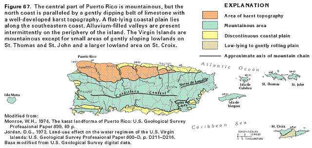
Geologically speaking, the Virgin Islands and Puerto Rico were once one landmass millions of years ago, according to geologists. This geological process influenced trees and animal species on the islands’ botanical forest development. Puerto Rico is the easternmost and smallest island of the Greater Antilles. It is bound on the south side by the Caribbean Sea and on the north side by the Atlantic Ocean.
The island land area is roughly 3,424 or 3,459 square miles. There are several small islands surrounding the island of Puerto Rico. On the west are Desecheo and Mona. The south includes many inlet cays and Caja de Muertos island. On the east is Culebra, Vieques, and the U.S. and British Virgin Islands. From the standpoint of geologic history, the small islands represent parts of the greater Puerto Rican land mass, now fragmented by subsidence and submergence in the ocean.

However, it is logical to treat the islands together as a botanical unit, because very few of the plants occurring on the smaller islands don’t grow on the mainland of Puerto Rico. On the other hand, there are plants endemic to Puerto Rico and the Virgin Islands and might not be found anywhere else in the world. This also goes for animal species like the native Virgin Islands Tree Boa (Chilabothrus grant) found on St. Thomas, Tortola, Culebra, and Mona Island, west of Puerto Rico, but not on the mainland of Puerto Rico.
Nevertheless, endemic simply means something is consistently present, found regularly, or native to a specific geographic area or population. Therefore, it is important to know the geological history that helps to explain present tree distribution in the Virgin islands and Puerto Rico. Puerto Rico and the adjacent islands began as submarine volcanoes on the ocean floor, according to geologists, some 125 million years ago and were built by the end of the Cretaceous period, which was about 80 million years ago.
One would say there was sufficient time through millenniums for much accidental migration of plants and animals from the landmass of Puerto Rico to have occurred to the adjacent islands. There is evidence geologists found that much higher mountain peaks may have existed, that blocks have been uplifted and subsided, and that sea level may have fluctuated during the early Cretaceous period. Another factor to consider is during the glacial periods the climate may have been cooler, vegetation zones as much as 3,000 feet lower, and sea level 200 feet lower.
The island of Puerto Rico, however, is of great geologic and topographic complexity. Although large parts of Puerto Rico are igneous in origin, it shouldn’t be called a “volcanic island.” Geologists believe because the volcanic events that affected Puerto Rico’s form and structure occurred many millions of years ago, it had enormous changes that occurred caused by erosion, accumulation of sedimentary deposits, uplift, tilting, submergence, faulting and folding of the island’s geological development.
Like the island of St. Croix, Puerto Rico divided into three physiographic areas. They are the coastal lowlands, the karst limestone along the northern side of Puerto Rico, and the upland region — geologic structure, which includes numerous small limestone outcrops, especially toward the southwest of the island. Then, there is the Sierra de Luquillo mountain range in the east of the island with a peak 1,640 feet above sea level.
El Toro Mountain range, at 3,526 feet, and El Yunque mountain, at 3,461 feet above sea level, also play a major role along with the more extensive Cordillera Central Mountain region forming the “backbone” of Puerto Rico’s highest peak, Cerro de Punta, at 4,390 feet above sea level. Whereas St. Croix also is divided into three parts like the landmass of Puerto Rico, we will focus in the northwest and northeast central region of St. Croix since we are discussing the forest development in Maroon Park.
First, if you noticed, there is a short ridge lying northwest and southeast and containing the highest peaks of St. Croix, namely Blue Mountain (1,096 feet) at its southern end and Mount Eagle (1,165 feet) at its northern end. These mountain ranges are the most conspicuous feature of St. Croix. Thus, they are an important feature of St. Croix’s geography. Intermittent streams in these high elevations drain into the deep cut valley of the forest on the eastern side and turn to the northeast (Mt. Eagle), and finally flow out by the stream known as Salt River Bay on the northern shore of the island.
On the western side are steep valleys, with the drainage turned southwards and flowing out on the southern shore of the island. Salt River Hills on the northeast is the highest point of which toward its east end is 872 feet above sea level. The spurs of this range press onto the sea shore, to reach the valley, which in part marks off the range from Mount Eagle Ridge. However, on the west side of Mount Eagle are low hills that connect with an extensive group block of hills than a range.
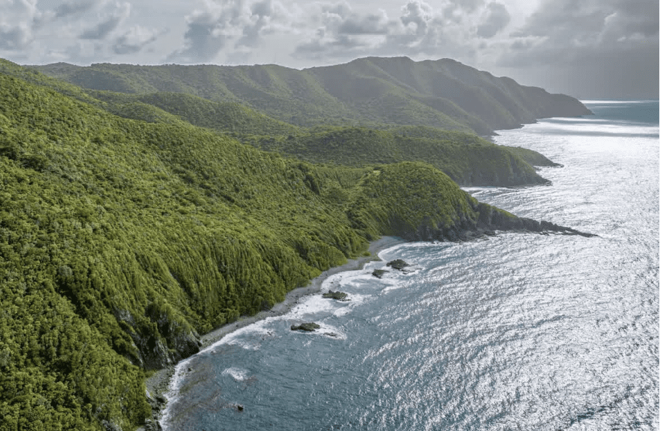
These blocks of hills are within the Maroon Sanctuary Park Forest that make up the northwestern corner of St. Croix, with some elevation over 800 feet and almost 1,000 feet above sea level. The rolling hills or low mountains of the northside of St. Croix of the western oblong are all connected by lower elevations and may be regarded as consisting of three parts within the Maroon Sanctuary Park.
The Mount Eagle Ridge, Salt River Hills to the east of that ridge, and the northwestern block of hills to the west of it, are the three dividing topographies in Maroon Country on St. Croix. Like Puerto Rico, St. Croix was never a volcanic island, but volcanoes played an indirect role in its formation. For this and other reasons, the forest development within Maroon Country plays a great role in species development of plants due to its higher elevation, more than any other part of the island.
The highest rainfall on St. Croix is within the Maroon Park. Estate Annaly is within the park with a rainfall of 50 to 60 inches of precipitation in a normal year. In Part 2 of this series, I will explain the forest development of Maroon Sanctuary Park.
— Olasee Davis is a bush professor who lectures and writes about the culture, history, ecology and environment of the Virgin Islands when he is not leading hiking tours of the wild places and spaces of St. Croix and beyond.
Editor’s Note: Opinion articles do not represent the views of the Virgin Islands Source newsroom and are the sole expressed opinion of the writer. Submissions can be made to visource@gmail.com.


