Updated 9/29/24 at 6:02 p.m. AST
Weather updates are posted by Jesse Daley, who has been reporting on weather for the Source since 2022 and holds an Undergraduate Certificate in Weather Forecasting from Pennsylvania State University.
VI SOURCE WEATHER UPDATES
! The National Weather Service in San Juan, Puerto Rico, has explained that excessive heat will continue across the U.S. Virgin Islands and Puerto Rico on Monday. Please stay hydrated and cool.
MONDAY’S WEATHER FORECAST: 9/30/24
Happy Monday!
According to the National Weather Service (NWS) in San Juan, Puerto Rico, Monday will be mostly sunny, with a chance of scattered showers and thunderstorms. An area of high pressure will be near the region, helping to limit the chance of precipitation. The high temperature will be approximately 89°F, 31.6°C. The heat index will be high, making the temperature feel even warmer. Winds will be out of the east at roughly 7 to 11 mph. The chance of rain on Monday is approximately 30 percent.
Monday night will be mostly clear, with a chance of isolated showers. The low temperature will be approximately 80°F, 26.6°C, with winds out of the east-northeast at roughly 8 to 10 mph. The chance of rain on Monday night is approximately 20 percent.

Yellow = Limited Risk, Orange = Elevated Risk, Red = Significant Risk
Below: Infrared satellite imagery obtained at 5:30 p.m. AST on Sunday indicates a partly cloudy sky across the USVI and Puerto Rico. Rainfall and thunderstorms are possible.

MARINE WEATHER UPDATE
The NWS has noted that wave heights will reach approximately 3 to 5 feet on Monday. Winds during the daytime will be out of the east at approximately 5 to 10 knots.
The water temperature is approximately 86-87°F, approximately 30-30.5°C.
Ocean Water Temperature Map from 9/27/24, courtesy of NOAA:

Wave Height Forecast Map courtesy of NWS:

HAZARDOUS CONDITIONS
Thunderstorms: The NWS has noted that isolated showers and thunderstorms are possible over the local waters.
Rip Currents: On Monday, the risk of rip currents is projected to be moderate across most of the region.

Clear = Low Rip Current Risk, Yellow = Moderate Rip Current Risk, Red = High Rip Current Risk
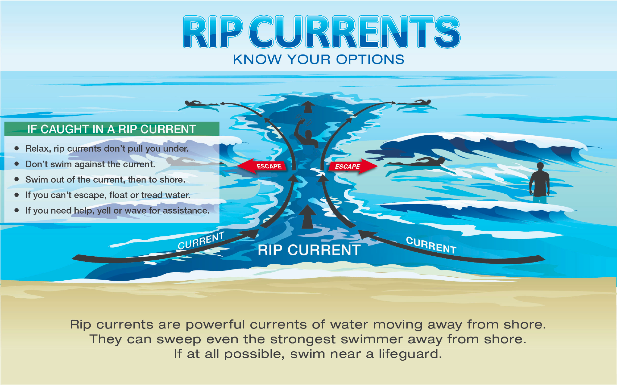
Learn more about rip current safety in an interview between the NWS and the VI Source here.
TROPIC WATCH


Tropical Activity:
The National Hurricane Center (NHC) is monitoring several areas, including Hurricane Isaac in the Northern Atlantic, Tropical Storm Joyce in the Central Atlantic, Tropical Depression in the Eastern Atlantic, and an area in the Western Caribbean and another in the Eastern Atlantic for possible cyclonic development.
At this time, no systems threaten the U.S. Virgin Islands. However, the Climate Prediction Center’s Global Tropics Hazards Outlook indicates the potential for cyclonic development over the next couple of weeks. The weather can change quickly, and residents and visitors in the USVI are encouraged to follow the NHC for the latest tropical updates.
Click here for tips on remaining prepared during the 2024 Atlantic Hurricane Season.
Days Remaining in the 2024 Atlantic Hurricane Season: 61 Days
OBSERVATIONS
Sunrise: 6:11 a.m.
Sunset: 6:11 p.m.
The water temperature is approximately 86-87°F, approximately 30-30.5°C.
UV index: 10 out of 10 (VERY HIGH)
Sunday’s high temperature: 89°F, 31.6°C
Sunday’s low temperature: 81°F, 27.2°C
Preparation for extreme weather events in the Caribbean, such as earthquakes and tropical cyclones, is important. Residents and visitors in the USVI are encouraged to stay updated on weather events on the V.I. Source Weather page and sign up for alerts from the National Weather Service and the Virgin Islands Territorial Emergency Management Agency.
Article Series: “Extreme Weather in the Caribbean”
- Part 1: Caribbean Earthquakes and Tsunamis
- Part 2: Caribbean Volcanoes
- Part 3: Rip Currents
- Part 4: Hurricanes
- Part 5: Wildfires
- Part 6: Flash Floods
- An article about earthquakes in the Caribbean is available here!
- An informational video about drought conditions in the USVI is available here!
- Article: Colorado State University Predicts Extremely Active 2024 Atlantic Hurricane Season
- Article: La Niña Weather Pattern May Spawn an Active 2024 Atlantic Hurricane Season
- Article: NOAA Forecasts Above-Average 2024 Hurricane Season, Expects High Number of Named Cyclones