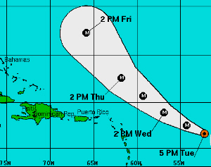
By the time it’s northeast of the Virgin Islands, it’s expected to be a "low end" Category 4, a major hurricane.
"We might get some outer bands [of rain] over us," Brian Seeley, a meteorologist at the National Weather Service in San Juan said Tuesday.
According to Seeley, harbors exposed to the east will see the most swells. He expects the wind gusts to reach 15, 20 or maybe even 25 mph.
It seems reasonably certain that Bill will continue on the same track because the models are consistent, Seeley said. "There’s not much waffling," he said.
However, he said that residents should keep their weather eye out in case the situation changes.
Residents should also expect a strong tropical wave on Sunday. "There’s a nice surge of wind, and it will bring showers," he said.
As of the 5 p.m. update from the National Hurricane Center, Bill was centered at 16.6 degrees north latitude and 52.5 degrees west longitude. Winds were at 110 mph, with gusts to 125 mph. The hurricane is expected to strengthen even further over the next day or two and will become a major hurricane Wednesday.
Hurricane force winds extend out 45 miles, with tropical storm force winds reaching out 175 miles.
The barometric pressure stands at 962 millibars or 28.4 inches. The storm was moving west-northwest at 16 mph.


