
Tropical Storm Erin formed Monday in the eastern Atlantic and is forecast to strengthen into a hurricane later this week, the National Hurricane Center said. It remains too early to determine whether the storm will impact the U.S. Virgin Islands or Puerto Rico.
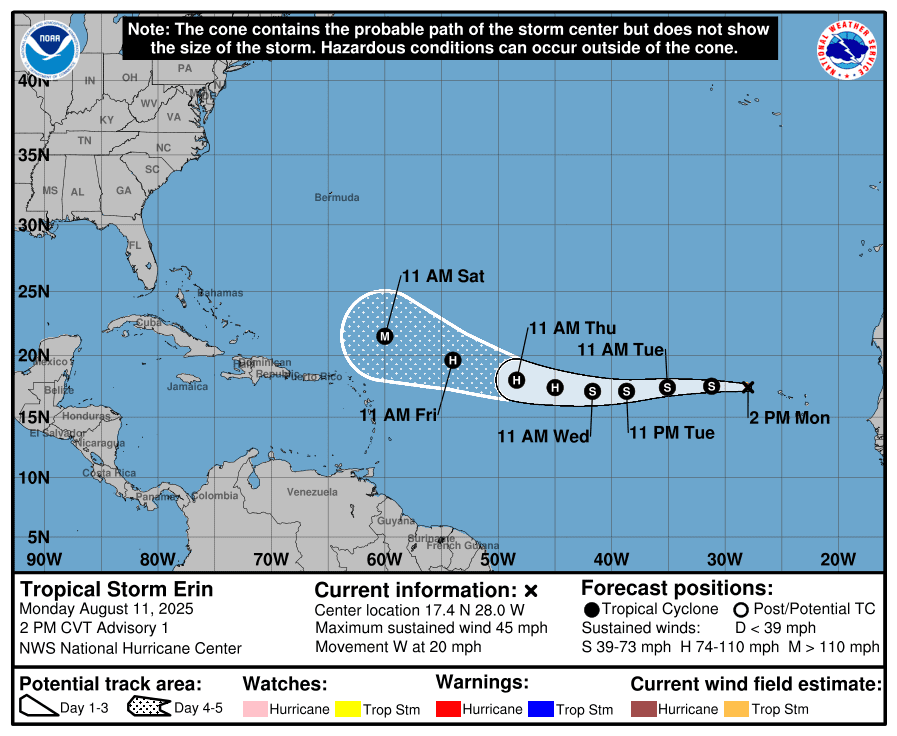
As of the NHC’s 2 p.m. Monday update, Erin, the fifth named cyclone of the 2025 Atlantic hurricane season, was located about 280 miles west-northwest of the Cabo Verde Islands off the west coast of Africa.
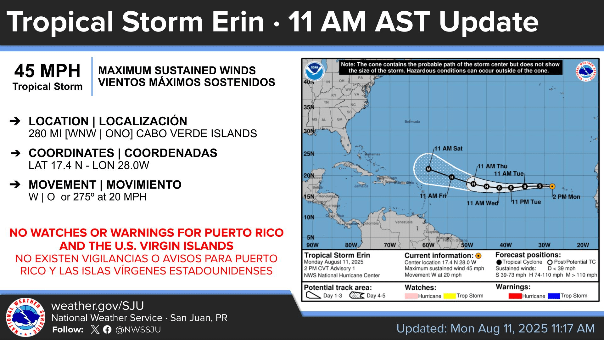
“At 11:00 AM AST on Monday, the center of Tropical Storm Erin was located near latitude 17.4 north, longitude 28.0 west. Erin is moving toward the west near 20 mph, and this motion is expected to continue for the next several days,” according to the update from the NHC. “Earlier satellite wind data indicated that maximum sustained winds are near 45 mph with higher gusts. Gradual strengthening is forecast over the next several days,” the NHC said.

The Track of Tropical Storm Erin
The NHC expects Tropical Storm Erin to continue on a westward path for the next several days before gradually turning northwest later in the week. Forecasters say the storm will likely strengthen slowly at first due to cooler waters and dry air, but could intensify more quickly as environmental conditions improve. The NHC forecast shows the turn to the northwest happening near the end of the five-day outlook, when Erin is east of the Leeward Islands.
However, while Erin may pass northeast of the U.S. Virgin Islands and Puerto Rico, the National Weather Service in San Juan, Puerto Rico, cautioned Monday that it is still too early to determine whether there could be any direct impacts across the local islands. The NWS did mention the possibility of rough seas due to Tropical Storm Erin.
“At this time, model guidance suggests it will track well northeast of the region, approximately 250 to 300 miles northeast of San Juan, though it could still affect the local region indirectly by generating marine and coastal hazards over the upcoming weekend, particularly across Atlantic waters and north-facing beaches,” the NWS explained.
“Since it is still too early to determine any direct impacts on our region, residents and visitors are encouraged to stay informed and monitor future forecasts, as updates will be issued regularly,” the NWS advised.
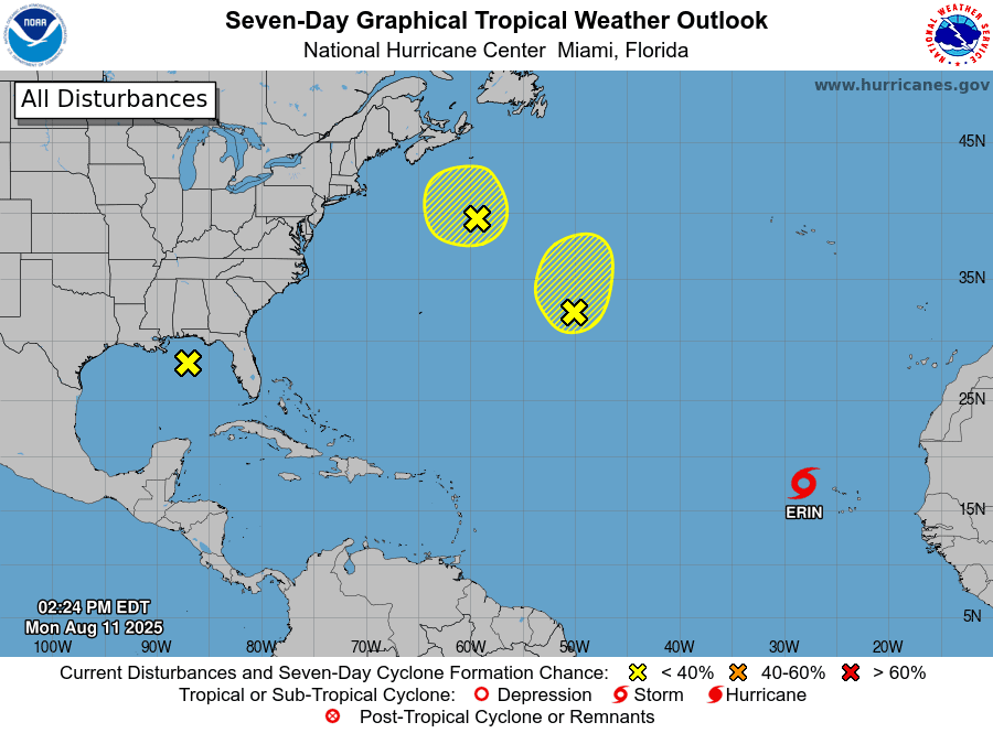
In addition to Tropical Storm Erin, the NHC is tracking other areas across the Atlantic basin, including “Invest 96L” in the central Atlantic, located northeast of Puerto Rico and the USVI, and another disturbance in the northwestern Atlantic. As of Monday, both systems have a low chance of development. The NHC is also monitoring a cluster of showers and thunderstorms in the Gulf, which currently has no potential for development.
Comparisons to Initial Track of Hurricane Irma
Several reports circulating online have compared Erin’s early track to that of Hurricane Irma in 2017, raising fears of a repeat scenario. The Source reached out to Alex DaSilva, lead hurricane specialist at AccuWeather, to address these concerns.
“When you have a hurricane or a tropical storm that far east in the Atlantic, you have to monitor it very carefully,” DaSilva said. “In 2017, at the very beginning in the early forecasts, Irma looked like it was going to go safely out to sea, and then the trends brought it a little bit farther south,” he explained.
DaSilva said current computer forecast models point to Erin passing north of the U.S. Virgin Islands and Puerto Rico, though forecasters will continue to watch the storm closely. He noted Erin is likely to become an intense cyclone, with rip currents and choppy seas expected.
“The waters are very warm, and the disruptive wind shear will be very low, which will allow this storm to rapidly intensify north and east of the islands before beginning a turn to the north,” DaSilva stated. “Later this week, the waves will really begin to pick up along the islands, and dangerous rip currents are expected as Erin strengthens and passes by to the north and east of the islands.”
“Keep checking forecast updates daily and stay connected. Don’t let your guard down this hurricane season,” DaSilva added.
Local Weather Information and Staying Informed
On Monday, the NWS in San Juan reminded residents of Puerto Rico and the USVI to remain aware of weather-related threats in the coming days. These include periods of rainfall and thunderstorms, partly due to trailing moisture from “Invest 96L,” a tropical system located northeast of the islands. Very warm temperatures are expected to persist, with the possibility of heat alerts. In addition, a plume of Saharan dust is forecast to arrive Monday night, reducing air quality and creating hazy conditions through midweek. On the bright side, this dry desert air can help limit tropical cyclone development and intensification.
More tropical waves are anticipated to emerge off the west coast of Africa in the coming days, and USVI residents and visitors are encouraged to continue to remain prepared. It is crucial to remember that the forecast can change very quickly. USVI residents and visitors are encouraged to continue to remain prepared. Weather information is available from the NWS, the NHC, and NOAA.
Additionally, the local weather forecast for the U.S. Virgin Islands is regularly updated on the Source Weather Page and VI Source YouTube Channel. A weekly Tropical Outlook article from the Source is also published throughout hurricane season to provide in-depth updates.
Residents and visitors can find additional weather alerts and preparedness information from the Virgin Islands Territorial Emergency Management Agency.


