
Atmospheric and oceanic conditions across the Atlantic basin are becoming increasingly supportive of tropical development. With warm sea surface temperatures and a gradual reduction in wind shear, forecasters say the environment is shifting toward a more active pattern as August progresses.
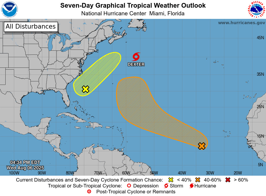
As of Wednesday afternoon, the National Hurricane Center was monitoring several areas across the Atlantic basin, including Tropical Storm Dexter, spinning in the Atlantic Ocean, several hundred miles south of Newfoundland. Additionally, there is a disturbance being monitored off the southeast coast of the U.S. mainland with a low chance of development.
There is also a tropical wave located in the eastern-central Atlantic with a greater chance of organizing into a cyclone and potentially intensifying into a tropical depression in the coming days. The wave is currently moving across the Atlantic.
“Shower and thunderstorm activity has become a bit more concentrated with a tropical wave in the eastern-central tropical Atlantic,” according to an update on Wednesday from the NHC. “Environmental conditions are forecast to be conducive for gradual development during the next few days, and a tropical depression could form late this week or over the weekend as the system moves generally west-northwestward to northwestward across the central tropical and subtropical Atlantic,” the NHC said.

An update at 2 p.m. EST on Wednesday from the NHC indicates that the disturbance may pass northeast of the Lesser Antilles. However, the NWS office in San Juan, Puerto Rico, has noted that two of the widely-used forecast models — Global Forecast System and the European Centre for Medium Range Weather Forecasts model — are not in complete agreement on the possible storm track. The NWS has advised residents and visitors across the U.S. Virgin Islands and Puerto Rico to monitor the progress of the system.
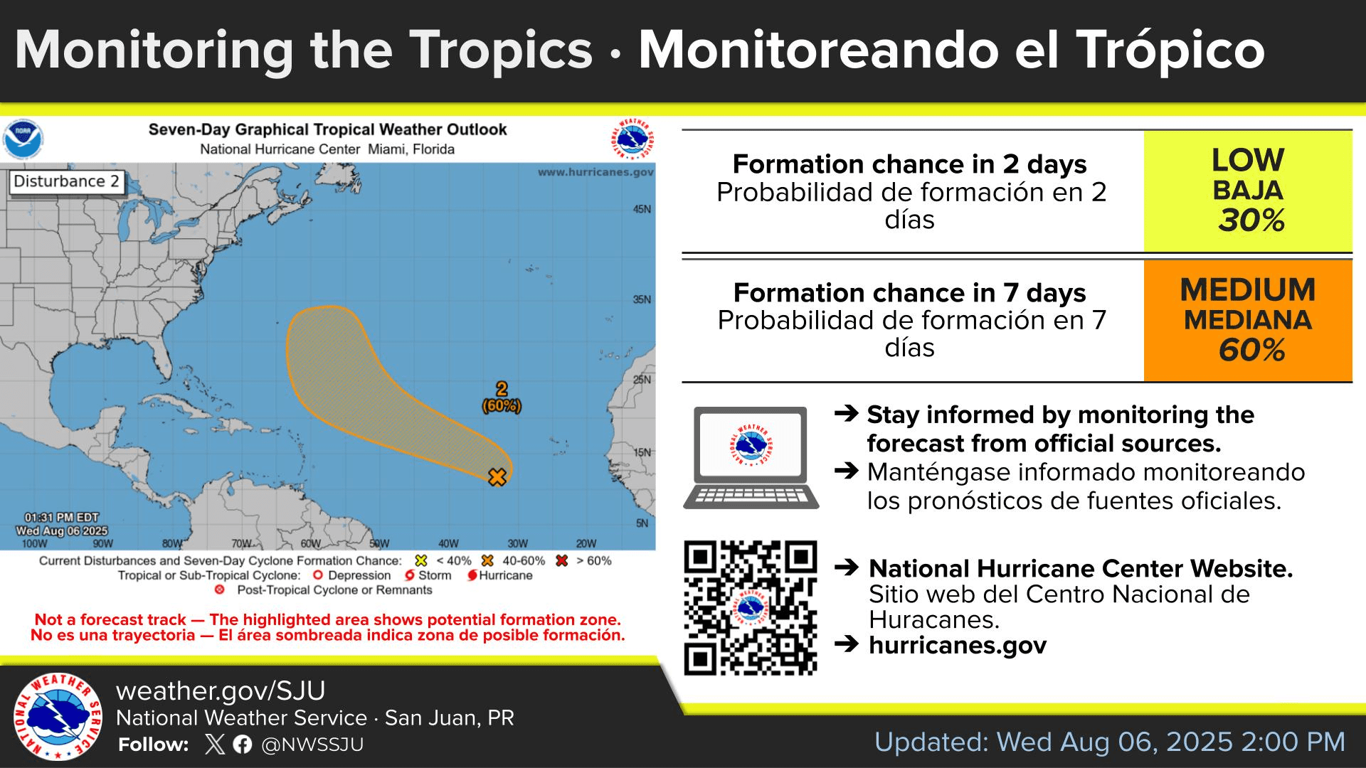
“Given current trends, the long-term forecast leans toward the U.S. Global Forecast System, which supports a deterioration in weather conditions after Monday, with increasing moisture, instability, and a rising flood risk across Puerto Rico and the U.S. Virgin Islands through at least Tuesday,” the NWS explained in an update on Wednesday. “That said, forecast confidence remains low, and it is too early to specify exact impacts for the region,” the NWS added.
“Residents, visitors, and emergency managers are strongly encouraged to closely monitor the forecasts from official agencies, particularly from the NHC and the NWS San Juan forecast office, as confidence is expected to improve in the coming days,” the NWS said.
NOAA Global Tropics Hazards Outlook
Tropical development is expected to become more likely as we move deeper into August, according to a Global Tropics Hazards Outlook released Tuesday. The forecast tool, which is released weekly by the National Oceanic and Atmospheric Administration’s Climate Prediction Center, offers insight into potential developments across tropical basins up to three weeks in advance.

In its latest update, NOAA highlighted areas across portions of the Caribbean as well as within the Main Development Region — the zone between the west coast of Africa and the Caribbean — as having increased chances for tropical activity in the coming weeks. The Eastern Pacific basin, which has been active in recent weeks, is also expected to maintain an elevated opportunity of cyclonic development.
Conditions Becoming More Favorable for Development
Alex DaSilva, lead hurricane specialist at AccuWeather, shared information about favorable environmental conditions for storm development and the possibility of an increased chance of cyclonic activity in comments provided to the Source on Wednesday.
“We’re now into August and getting closer to the statistical peak of the hurricane season, which is in early September,” DaSilva said. “We are seeing warmer ocean temperatures, less wind shear overall, and less dry air as well. We’ve seen some of that Saharan dust back off a little bit, and we’ve also seen some of that wind shear back down across the Atlantic basin. We are also seeing ocean heat content increasing across the Main Development Region. Ocean heat content is essentially the depth of the warm water and how deep it extends below the surface of the sea,” DaSilva explained.
In addition to warmer sea surface temperatures and reduced wind shear across parts of the Atlantic basin, DaSilva cited a weather phenomenon known as the “Madden-Julian Oscillation.” The NWS defines the MJO as “an eastward moving disturbance of clouds, rainfall, winds, and pressure that traverses the planet in the tropics and returns to its initial starting point in 30 to 60 days on average.”
“We’ve seen an MJO wave passing through the area,” DaSilva stated. “That can enhance some showers and some thunderstorms, potentially leading to some development in the days that it comes through and even some days after it passes through, because it can affect some of the tropical waves over Africa,” DaSilva said.
Closely Watching the Tropics
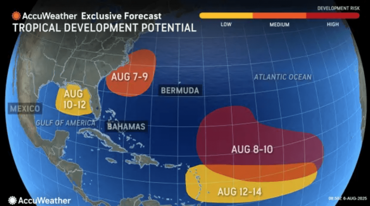
Responding to questions about threats across the USVI and Puerto Rico, DaSilva noted that the NHC is continuing to monitor a tropical wave currently moving across the Atlantic Ocean. However, he told the Source that he is more troubled about a second tropical wave that is forecast to emerge off the west coast of Africa in the coming days, which could potentially track close to the Caribbean.
“I am concerned about the next wave coming off Africa in the next day or so, and by the middle of the month is when we’re looking for something to approach the Virgin Islands potentially,” DaSilva said. “The Bermuda High — a semipermanent area of high pressure in the North Atlantic Ocean — might be a little bit stronger, which may allow this to come much closer to the Virgin Islands. It is still possible that this second wave turns out to sea. However, I think it’s going to get at least closer to the islands than the first wave does,” DaSilva continued.
“The overall pattern is a bit more supportive of something coming a little bit closer to the Virgin Islands, and it could potentially be a hurricane,” DaSilva cautioned. “Therefore, we need to keep a very close eye out for the middle of the month for something to possibly approach the Lesser Antilles and the Virgin Islands.”
Indeed, in an emailed notice Wednesday, meteorologists at the NWS in San Juan also shared information about a potential system approaching the local region during the middle of August. Still, the NWS noted that the forecast can change, and the agency reminds individuals to stay updated on the weather conditions.
“Some global forecast models indicate the possible cyclonic formation later in August,” the NWS said. “However, given its long-range nature, confidence in the forecast is very low at this time. No action is needed for now, but staying informed is essential,” the NWS said in a message on Wednesday.
Notably, a forecast released Wednesday by Colorado State University’s Tropical Cyclones, Radar, Atmospheric Modeling, and Software Team predicts an increase in tropical activity between Aug. 6 and Aug. 19.
Local Weather Updates
It is crucial to remember that the forecast can change very quickly. USVI residents and visitors are encouraged to continue to remain prepared. Weather information is available from the NWS, the NHC, and NOAA.
Additionally, the local weather forecast for the U.S. Virgin Islands is regularly updated on the Source Weather Page and VI Source YouTube Channel. A weekly Tropical Outlook article from the Source is also published throughout hurricane season to provide in-depth updates.
Finally, residents and visitors can find weather details and preparedness information from the Virgin Islands Territorial Emergency Management Agency.


