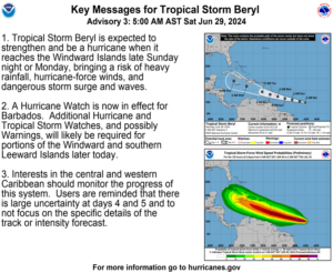
Tropical Storm Beryl has formed in the Atlantic Ocean. The National Hurricane Center expects the system to intensify into a hurricane as it passes to the south of the Virgin Islands and Puerto Rico early this week.
“Tropical Storm Beryl is expected to strengthen into a hurricane [by the time] it reaches the Windward Islands late Sunday night or Monday, bringing a risk of heavy rainfall, hurricane-force winds, and dangerous storm surge and waves,” according to an update from the NHC on Saturday.
“A Hurricane Watch is now in effect for Barbados, [and] additional Hurricane and Tropical Storm Watches, and possibly Warnings, will likely be required for portions of the Windward and southern Leeward Islands later today,” the NHC said.
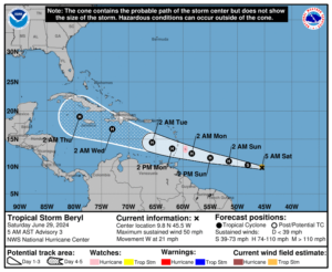
The NHC has noted that as of 5 a.m. on Saturday, TS Beryl is packing maximum sustained winds of approximately 50 mph and is traveling toward the west at 21 mph. Conditions are favorable for additional strengthening, including potentially undergoing rapid intensification due to favorable environmental conditions.
Cyclone Expected to Stay South of USVI, Puerto Rico
Beryl is forecast to pass a couple hundred miles south of the Virgin Islands and Puerto Rico between Monday and Tuesday. However, regardless of the cyclone’s proximity to the local islands, the National Weather Service explained that although the V.I. and Puerto Rico may not receive direct impacts from Beryl, indirect impacts, including the potential for rain and hazardous marine conditions, can be anticipated over the coming days.
Importantly, the forecast and the storm track can change quickly. It is crucial for residents and visitors across the region to monitor the situation closely.
“The latest [computer] model guidance suggests that Beryl will stay well south of the local islands as a category two hurricane,” according to an update from the NWS in San Juan, Puerto Rico, on Saturday.
“At this moment, the closest point to Puerto Rico and the U.S. Virgin Islands will be on Tuesday,” the NWS noted. “Despite this system staying south of the islands over the Caribbean waters, a broad field of moisture and external bands could reach the local area,” the NWS said.
“Therefore, an increase in showers and thunderstorm activity associated with this system is anticipated. With the expected conditions, some potential hazards [include] flooding, mudslides, and river rises [next week],” the NWS added.
A strong area of high pressure in the Atlantic is influencing the storm track of TS Beryl, and the system is expected to continue to move in a west-northwesterly direction. However, there is still uncertainty about the cyclone’s path, particularly in about four or five days.
“Interests in the central and western Caribbean should monitor the progress of this system,” the NHC advised. “[Individuals] are reminded that there is large uncertainty at days four and five, and to not focus on the specific details of the track or intensity forecast.”
NHC Watching Other Tropical Disturbances
In addition to Tropical Storm Beryl, the NHC is closely monitoring another tropical wave traveling across the Atlantic behind Beryl. The disturbance is forecast to move past the V.I. and Puerto Rico Thursday after TS Beryl passes through the region.
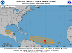
“[Computer] model guidance suggests the development of this wave and moving this system close to the local area by Thursday,” the NHS said. “Similar to Beryl, this wave is not expected to have direct impacts over Puerto Rico and the U.S. Virgin Islands. However, it is expected to bring shower activity over the region,” the NHC continued.
Finally, the NHC is watching “Invest 94L,” a disturbance near the southwestern Gulf of Mexico. (An “invest” is an area under investigation for tropical development.)
As reported in a recent Source article, a very active 2024 season is possible because of several factors, including a transition from an El Niño weather pattern to La Niña and extraordinarily warm sea surface temperatures across the North Atlantic. The combination of these elements may contribute to an increase in cyclones developing this year. Notably, the NHC explained that it is exceedingly rare for a cyclone to develop in the central or eastern Atlantic this early in the season.
“Tropical Storm Beryl is one of only a few storms in history that have formed over the central or eastern tropical Atlantic this early in the year,” the NHC stated.
Weather Updates
USVI residents and visitors can find information regarding hurricane preparedness from the Virgin Islands Territorial Emergency Management Agency and the National Oceanic and Atmospheric Administration.
Weather forecast information, including severe weather alerts, is available from the VITEMA website and the National Weather Service.
The Source Weather Page also publishes a daily weather forecast and offers readers the opportunity to view weather forecast videos and disaster preparedness video segments.


