In the coming decades, where should development take place to meet the territory’s needs for housing, economic expansion, and upgrades in the infrastructure? Will cultural and environmental resources be protected? Who will decide, and how?
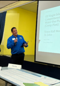
The blueprint for answering these questions is the Virgin Islands Comprehensive Land and Water Use Plan which is now in its drafting phase. The plan is expected to be submitted to the V.I. Legislature by August, according to Jean-Pierre “JP” Oriol, commissioner of the Department of Planning and Natural Resources.
Previous efforts to create a Comprehensive Land and Water Use Plan in the 1990s and again in 2004 stalled because of competing interests, Oriol said. The current draft is not a regulatory document – containing details of changes in the zoning code, for example – but more of a visioning document. Changes in regulations will follow in the next two or three years once the Comp Plan is adopted.
Oriol presented the results of the department’s ongoing efforts to several dozen St. John residents – many of whom were ancestral St. Johnians – on Monday evening at the Julius E. Sprauve School in Cruz Bay. This was the fourth series of public meetings held over the past 15 months to refine the plan and achieve community consensus.
This week, meetings are also being held. A meeting was held on St. Thomas on Tuesday evening at Victor’s Hideout and a meeting will be held on St. Croix at the University of the Virgin Islands’ Great Hall on Thursday. The two-hour sessions are scheduled to begin at 5:30 p.m.
At Monday’s meeting on St. John, community members were tasked with evaluating how much they agreed with the goals and strategies developed as part of the plan. Assisted by project consultants, residents worked in small groups to put green stickers next to strategies they agreed with, yellow stickers for items they liked but had concerns about, and red stickers for plans they disapproved of.

Although some groups responded positively to the majority of strategies proposed in the plan, other groups had qualms, especially about items that did not specify exactly who would be making the decisions.
In one group, several Coral Bay residents wanted assurance that their interests would be represented by an authority other than the Coral Bay Community Council (CBCC), which was named as part of a proposed strategy.

Although the CBCC has led efforts for responsible development and sustainability, one set of group members said the non-profit community organization does not take into account the desires of ancestral St. Johnians to develop their property for economic gain. “The government has relied too much on the CBCC,” said one retired educator.
Several groups also balked at the proposed strategy to “Execute the Initiatives of Plan Cruz Bay.” Plan Cruz Bay was a “charrette,” a one-week, intensive planning event held in June 2023 that was specifically designed to address planning issues in Cruz Bay.
That event, an initiative of Love City Strong, was primarily funded by Bloomberg Philanthropies and was conducted by the Horsley Witten Group and other experienced planners.
Using the input from more than 300 community members, the Plan Cruz Bay facilitators sketched out possible alternatives for the use of public space. Some of their designs can be seen by clicking here.
As part of the Plan Cruz Bay sessions, proposals were made to move the ferry dock from its present location in Cruz Bay to the Creek or Enighed Pond to cut down on congestion. Several meeting-goers on Monday said they were opposed to moving the dock from its traditional location.
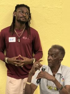
“You’re always throwing us in the back seat before you ask what we think!” said Kenneth Marsh.
His grandson, Kurt Marsh, who was part of the Plan Cruz Bay event, disagreed with him. “It was a very public, very open process. It wasn’t anything that came from the outside; it was the same people who are in this room tonight.”
Oriol assured the audience that no decisions had been made regarding the outcomes of Plan Cruz Bay because there was no consensus. He said more community meetings would be held to discuss that plan and asked the audience to focus for now on the territory-wide Comprehensive Land and Water Use Plan.
Although the meeting was scheduled to last two hours, most of those attending stayed an extra hour to engage Oriol on a number of other issues, including abandoned vehicles, allowing vessels to anchor in bays that are designated as restricted areas, and inadequate staffing for the library.
Theodora Moorehead brought up the issue of restoring municipal services to Coral Bay. “Coral Bay used to have a clinic, a school, a police station, a customs office. Now we have thousands of people on the island, but we don’t have any of these; we have gone backwards,” she said.
“The government struggles with the cost of services,” Oriol responded.
“As a government, we should prioritize,” she countered.
“I agree,” said Oriol.
Yvonne Wells asked Oriol for an update on the Summers End Marina, a 144-yacht marina project for Coral Bay that was approved by Coastal Zone Management 10 years ago but has been delayed for a number of reasons.

“The permit [from the Army Corps of Engineers] has still been deemed incomplete,” Oriol said, adding that several lawsuits are pending whose outcome could affect the validity of the original permit.
At the end of the meeting, Oriol said that because St. John is the smallest island, people think it will be the easiest to plan for. “But actually, St. John is our most complex island because a [large] percentage of the land is owned by the National Park Service. St John becomes more challenging because we’re trying to fit all of these services in a smaller area, and the [steep] topography comes into play.”
He reminded the meeting-goers that Delegate Stacey Plaskett has introduced a bill in Congress to limit the growth of the National Park on St. John.
Former Sen. Almando “Rocky” Liburd asked Oriol to continue to bring plans for St. John to the community for input. “People come to St. John for a reason. We don’t want to be like everywhere else,” he said.


