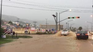
The National Weather Service has extended the Flash Flood Watch across the Virgin Islands for a third day, through Friday evening.This impacts much of Puerto Rico and the entire U.S. Virgin Islands and British Virgin Islands.
The proximity of an upper level trough and the abundance of tropical moisture will maintain unstable weather conditions across the region today. This may result in periods of enhanced showers with possible isolated thundershower development across the Virgin Islands through this evening. Daytime high temperatures are forecast in the low to mid 80s.
Be Prepared
A Flash Flood Watch means that conditions may develop that lead
to flash flooding. Flash flooding is a very dangerous situation.
You should monitor later forecasts and be prepared to take action
should Flash Flood Warnings be issued.
Across the regional waters, seas are expected between two to five feet today. Winds will continue from the east-southeast at 10-15 knots (12-17 miles per hour). Marine conditions may become hazardous around any thundershowers that develop over the local waters. There is a low to moderate risk of rip currents today.
Sunrise: 5:43 p.m.
Sunset: 6:52 p.m.


