
The National Hurricane Center is monitoring Tropical Storm Jerry as the cyclone approaches the Caribbean. Meteorologists expect the core of the storm to pass just to the northeast of the Northern Leeward Islands by Friday. Indirect impacts, including rainfall and choppy seas, are forecast across the USVI and Puerto Rico.
Tropical Storm Jerry: NHC Update
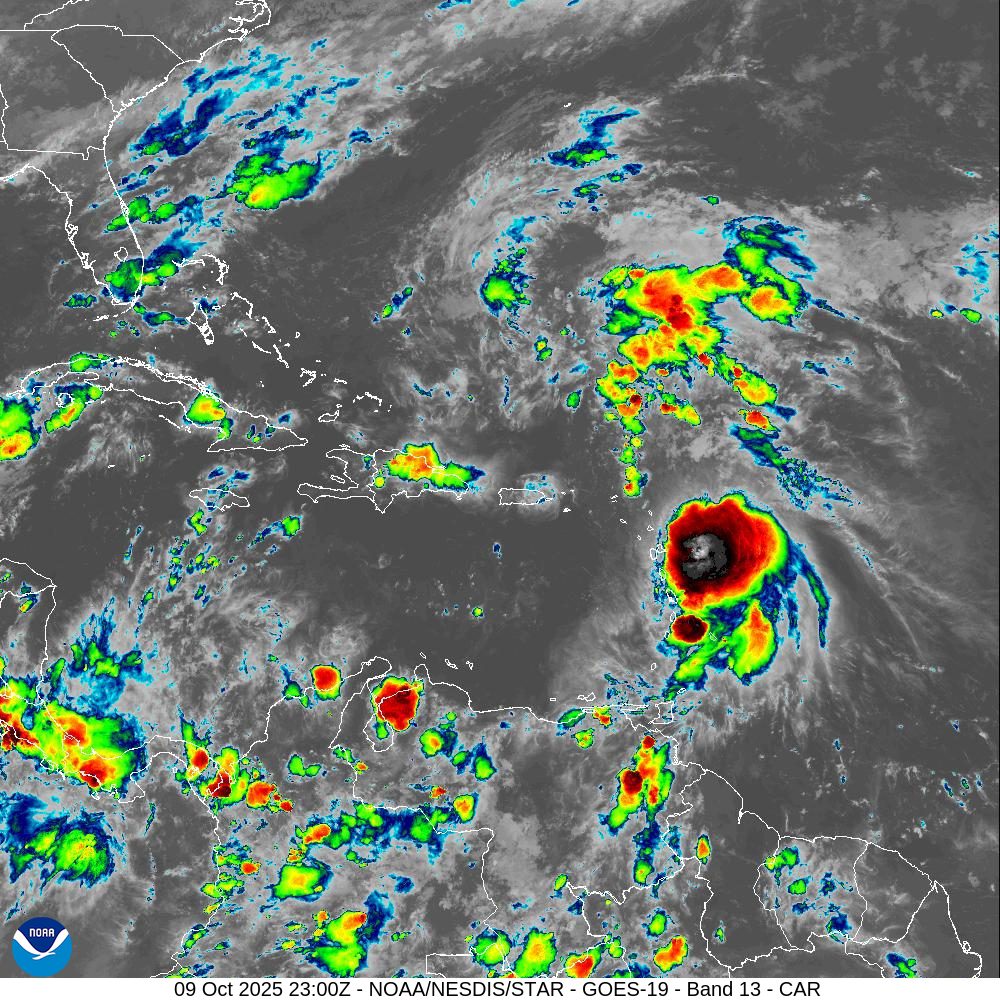
As of Thursday evening, Tropical Storm Jerry was located about 140 miles east-southeast of the Northern Leeward Islands, traveling toward the west-northwest, and packing winds of approximately 65 mph. Jerry may continue strengthening as it travels past the Lesser Antilles.
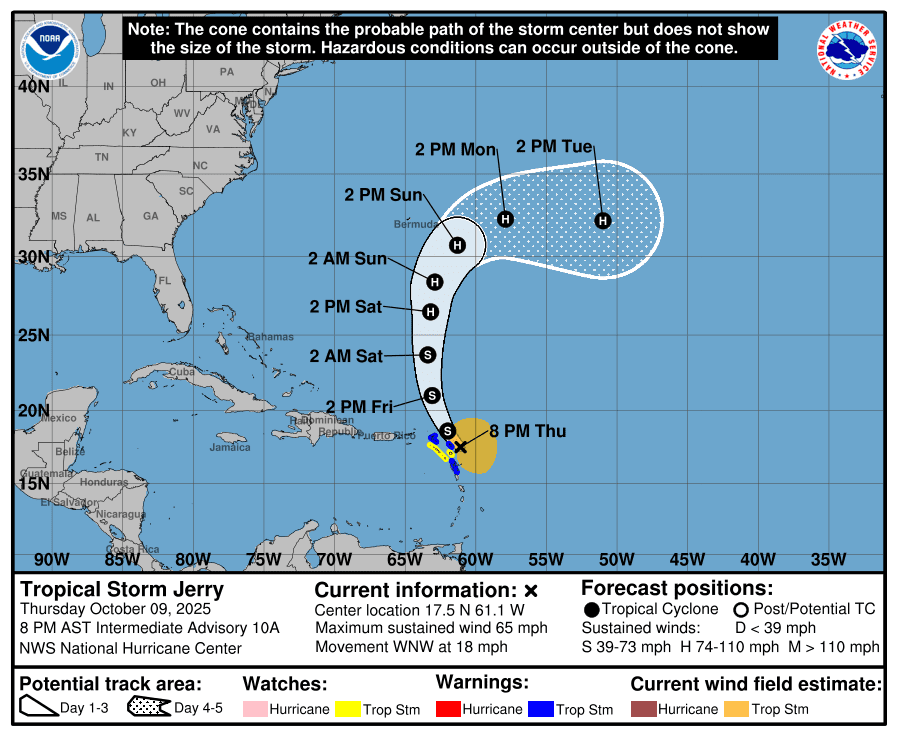
“At 8:00 p.m. AST, the center of Tropical Storm Jerry was located by Air Force Reserve reconnaissance aircraft near latitude 17.5 North, longitude 61.1 West,” according to an update from the NHC on Thursday evening. “Jerry is moving toward the west-northwest near 18 mph. A turn toward the northwest is expected later tonight, followed by a slightly slower northward motion on Friday and Saturday. On the forecast track, the center of Jerry is expected to pass near the northern Leeward Islands on Thursday night,” the NHC reported.
“Maximum sustained winds are near 65 mph with higher gusts. Little change in strength is expected through tomorrow, but slow strengthening is possible over the weekend.
“Tropical-storm-force winds extend outward up to 175 miles from the center of the cyclone, and the minimum central pressure estimated by aircraft dropsonde data is 1006 millibars,” the NHC said.
Due to the potential for the system to pass very close to several Caribbean islands, a tropical storm warning is now in effect for Barbuda and Anguilla, St. Barthelemy and St. Martin, Sint Maarten, and Guadeloupe and the adjacent islands.
A tropical storm watch is in effect for Antigua, St. Kitts, Nevis, and Montserrat, and Saba and St. Eustatius.
As of Thursday evening, no tropical cyclone alerts have been issued for the U.S. Virgin Islands or Puerto Rico.
Potential Impacts for the Virgin Islands and Puerto Rico
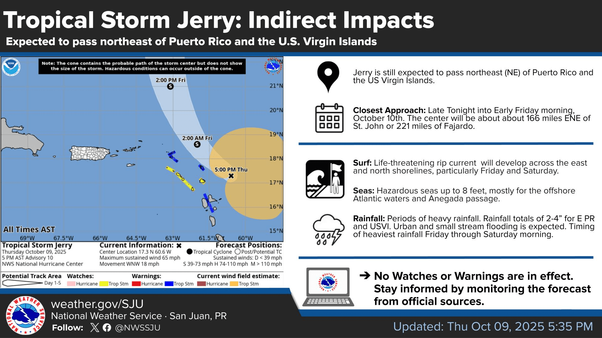
While meteorologists anticipate that the center of Tropical Storm Jerry will remain just to the northeast of the Northern Leeward Islands, indirect impacts are expected across the USVI and Puerto Rico, including rainfall and hazardous marine conditions. Weather conditions are forecast to deteriorate by Friday.
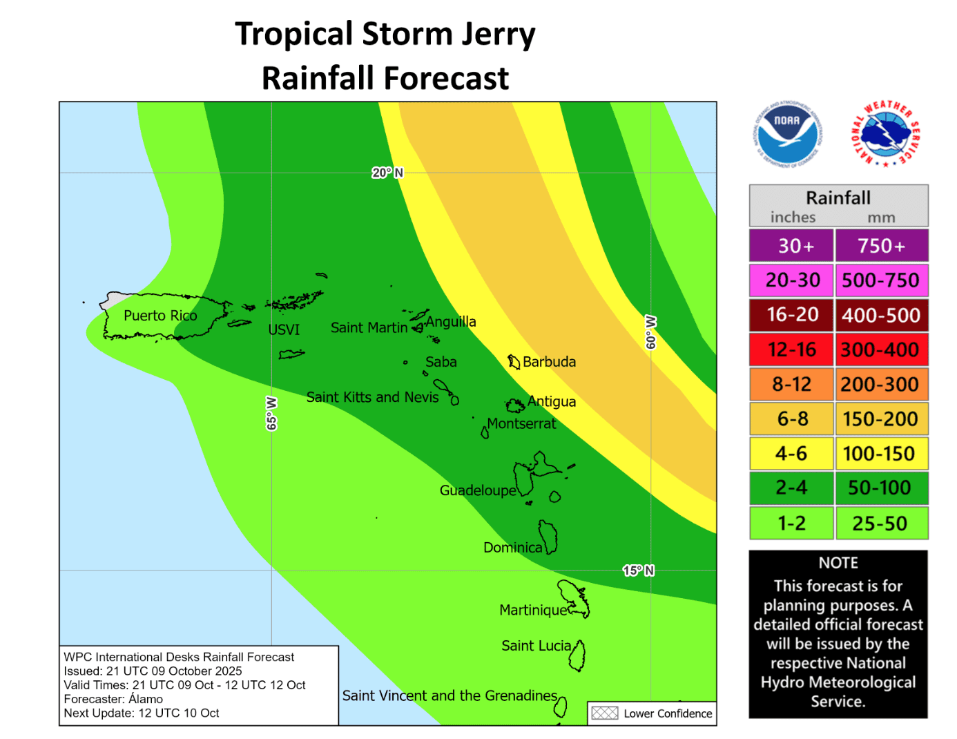
“Through Friday, two to four inches of rain with local rainfall totals up to six inches are expected across the Leeward and Virgin Islands,” the NHC warned. “This rainfall brings a risk of flash flooding, especially in urban areas and in steep terrain. For portions of Puerto Rico, moisture associated with Jerry combined with local orographic effects may result in up to two to four inches of rain, with isolated six inches possible.”
“Swells generated by Jerry are beginning to reach the Leeward Islands and Windward Islands,” the NHC said. “These swells will spread westward toward the Virgin Islands and Puerto Rico Thursday night, and then toward the rest of the Greater Antilles over the next couple of days. These swells are likely to cause life-threatening surf and rip current conditions.”
A Small Craft Advisory and a High Rip Current Risk have been issued for portions of Puerto Rico and the USVI, and the alerts will remain in effect until at least Saturday.
National Weather Service Monitoring Tropical Storm Jerry
The National Weather Service in San Juan, Puerto Rico, is closely watching Tropical Storm Jerry, noting that the cyclone’s core is forecast to remain at a safe distance away from the USVI and Puerto Rico. However, it is important for residents and visitors to be aware that any wobbles or shifts in the storm path could significantly affect weather conditions across the local islands.
“Deep tropical moisture from Jerry will help support rounds of showers and thunderstorms through the weekend, maintaining a moderate risk of flooding, mostly for eastern Puerto Rico and the Virgin Islands,” the NWS said on Thursday.” For the U.S. Virgin Islands, particularly St. Thomas and St. John, conditions could deteriorate further than in the rest of the forecast area. Periods of gusty winds, rough seas, and locally heavy rainfall are possible from Friday into the weekend,” the NWS warned.
“Dangerous marine conditions for small crafts and hazardous beach conditions are forecast, as swells from Jerry reach the regional waters by late Thursday night and continue into Saturday,” the NWS added.
VITEMA Press Briefing
On Thursday afternoon, Daryl Jaschen, director of the Virgin Islands Territorial Emergency Management Agency, held a press briefing from Government House on St. Croix to share information about the current tropical weather threats associated with Tropical Storm Jerry.
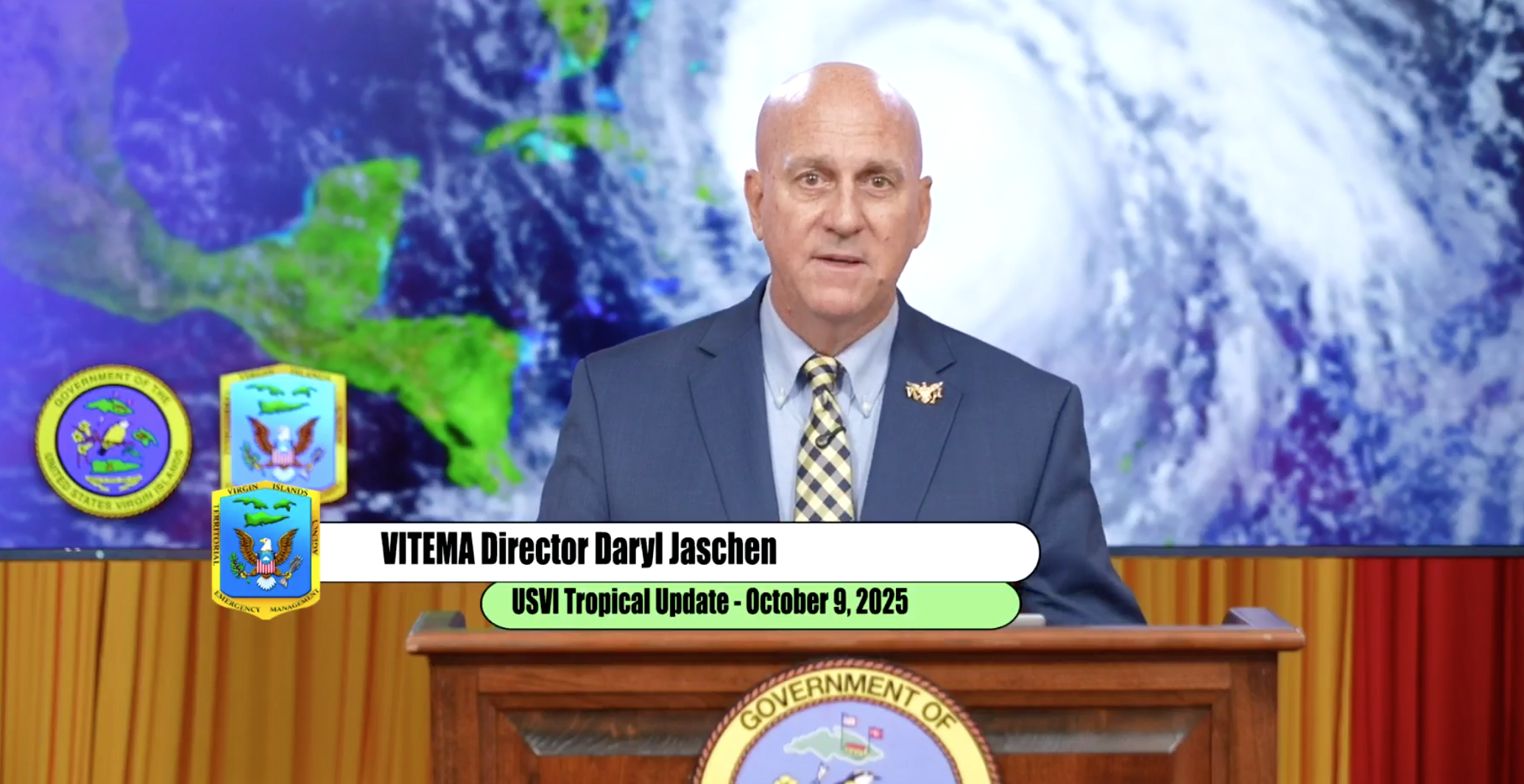
Jaschen emphasized that the NHC expects the storm to travel northeast of the local region, with its closest approach staying approximately 155 miles northeast of St. John. Still, he said that there will be a significant threat of hazardous seas and potentially heavy rainfall and the possibility of flash flooding.
“We are going to see some indirect impacts from Tropical Storm Jerry, including life-threatening rip currents, especially along the north shorelines of St. Thomas and St. John, and seas will rise to about eight feet,” Jaschen said.
“Between Friday night and Saturday morning, the USVI may receive two to four inches of rainfall, and some of the rainfall may be intense at times,” Jaschen stated. “The rainfall will primarily affect St. Thomas, St. John, and Water Island, but St. Croix will also receive some rain and thunderstorms due to outer rainbands.”
Jaschen said that even after Jerry’s departure, its trailing moisture could continue to bring unsettled weather to the islands.
“Conditions should improve by Saturday afternoon,” Jaschen noted.
Residents and visitors are encouraged to sign up for emergency weather alerts and review storm preparedness information available on VITEMA’s official website.
Looking Ahead
As was reported on Tuesday in a weekly Tropical Outlook article from the Source, according to a Global Tropics Hazards Outlook released Tuesday, there will continue to be an elevated chance of cyclonic development across portions of the Atlantic basin in the coming weeks. The forecast tool, which is issued every Tuesday by NOAA’s Climate Prediction Center, provides insight into potential activity across tropical basins up to three weeks in advance.
In its latest update, NOAA said that areas across a portion of the Main Development Region of the Atlantic basin — the zone between the west coast of Africa and the Caribbean — may experience a 20-40% chance of tropical development during the “Week Two” outlook period, which runs from Oct. 15 until Oct. 21. Development is not forecast across the Main Development Region in the “Week Three” outlook, running from Oct. 22 through Oct. 28.
However, according to the forecast, areas across the Western Caribbean Sea and the Gulf are likely to see an elevated chance of tropical cyclogenesis at times in October.
The Eastern Pacific basin, which remains active, is also expected to experience an increased risk for cyclonic development in the coming weeks.
On Thursday, NOAA reported that a La Niña weather pattern has developed. During a La Niña cycle, the ocean waters across the equatorial Pacific Ocean cool significantly, affecting global weather. During La Niña, wind shear — a change in wind direction and velocity with height in the atmosphere — also typically decreases in the Atlantic Ocean. A reduction in wind shear can favor cyclone development. This pattern is the opposite of “El Niño,” a warming of the equatorial Pacific, which usually increases wind shear in the Atlantic Ocean, helping to rip apart storms and prevent hurricane formation and intensification.
“Scientists call [the two opposing climate patterns of El Niño and La Niña] the “El Niño-Southern Oscillation” cycle. El Niño and La Niña can both have global impacts on weather, wildfires, ecosystems, and economies,” according to NOAA.
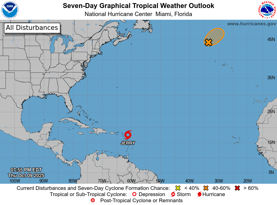
The development of La Niña could enhance tropical activity across the Atlantic through the remainder of hurricane season, which ends on Nov. 30. As of Thursday evening, the NHC was monitoring a disturbance in the North Atlantic in addition to Tropical Storm Jerry.
Additionally, a separate weather system could bring severe weather to portions of the East Coast of the U.S. mainland this weekend.
Stay Informed About the Weather
Finally, the NWS has reminded residents and visitors of ongoing weather-related threats across Puerto Rico and the U.S. Virgin Islands, including very warm temperatures which could prompt heat alerts.
The forecast can change very quickly, and USVI residents and visitors are encouraged to continue to remain prepared. Weather information is available from the NWS, the NHC, and NOAA. The local weather forecast for the U.S. Virgin Islands is also regularly updated on the Source Weather Page and VI Source YouTube Channel.


