
The 2025 Atlantic hurricane season officially begins on Sunday, and forecasters warn that conditions appear favorable for an active season. Meanwhile, another large plume of Saharan dust is expected to affect the local islands over the coming days.
The Atlantic hurricane season runs each year from June 1 until November 30, and multiple weather organizations, including the National Oceanic and Atmospheric Administration, AccuWeather, and Colorado State University’s Tropical Meteorology Project, have warned that the stage is set for a potentially above-normal season in terms of cyclonic activity.
While it’s impossible to predict precisely how a hurricane season will unfold, meteorologists base their seasonal outlooks on a combination of current atmospheric and oceanic conditions and decades of historical data to help project what could occur.
Key Factors in Place for a Busy Season
Forecasters closely monitor several key indicators, including sea surface temperatures and the El Niño–Southern Oscillation cycle, which encompasses the El Niño, La Niña, and ENSO-neutral phases and can significantly affect wind shear across the Atlantic Ocean. Experts also analyze forecasts for the West African Monsoon, which helps determine the frequency and strength of tropical waves emerging off Africa’s west coast. Many of these environmental signals appear favorable for tropical cyclone development this season.
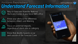
Still, it’s important to remember that it only takes one storm to make a season impactful. Both residents and visitors are urged to make preparations now, well before any potential threats emerge.
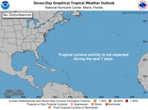
Indeed, while the Atlantic Basin has yet to record its first named storm of the year, NOAA’s Climate Prediction Center and meteorologists with AccuWeather have indicated the potential for cyclonic development in the Western Caribbean during the first half of June.
Additionally, tropical activity has already picked up in the Eastern Pacific. Tropical Storm Alvin recently formed off Mexico’s southern coast before being downgraded to a post-tropical cyclone. The NHC has given another low-pressure system in the same region a moderate chance of potential development.
Saharan Dust, Warm Temperatures to Affect Region
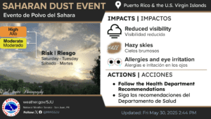
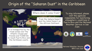
Along with the official start of hurricane season in the Atlantic, meteorologists at the NWS in San Juan, Puerto Rico, have warned that more Saharan dust is expected across the region over the next few days. Air quality is likely to be reduced, the sky will be hazy and temperatures are forecast to be very warm.
“An extensive and dense plume of Saharan Air Layer will affect the local islands from Saturday into the middle of the upcoming workweek,” the NWS said. “This will result in hazy skies, limited coverage in shower activity, and warmer conditions.”
“Individuals with respiratory conditions, such as asthma or allergies, should limit outdoor activities and use protective measures as needed,” the NWS stated. “Staying hydrated and avoiding strenuous outdoor exercise during peak heat hours is also recommended.”
Visitors and residents across the islands are encouraged to stay hydrated and remain as cool as possible during periods of extreme heat. More information about excessive heat safety is available from the NWS. Details about Saharan dust and potential health impacts, as well as how to stay safe during a dust event, are available from the Centers for Disease Control and Prevention.
Finally, boaters are also encouraged to exercise caution due to choppy seas generated by gusty winds, and swimmers are advised to be alert for the possibility of rip currents. Isolated thunderstorms are also possible.
Weather Forecast Information
In addition to obtaining weather information from the NHC, the NWS, and NOAA, the local weather forecast for the U.S. Virgin Islands is regularly updated on the Source Weather Page and VI Source YouTube Channel. Individuals can also find helpful weather information and alerts from the Virgin Islands Territorial Emergency Management Agency.


