
As meteorologists watch the tropics during the quiet winter months, a different kind of signal is drawing attention. The Pacific Ocean may pivot from La Niña toward El Niño later this year, a shift that can influence wind patterns and storm development across the Atlantic and Caribbean.
The 2026 Atlantic hurricane season is still months away, but meteorologists are already tracking the tropical Pacific for signs that El Niño could emerge. In its latest monthly update, the National Oceanic and Atmospheric Administration’s Climate Prediction Center recently said that a La Niña pattern is still present, but a transition to El Niño is increasingly likely in the months ahead.
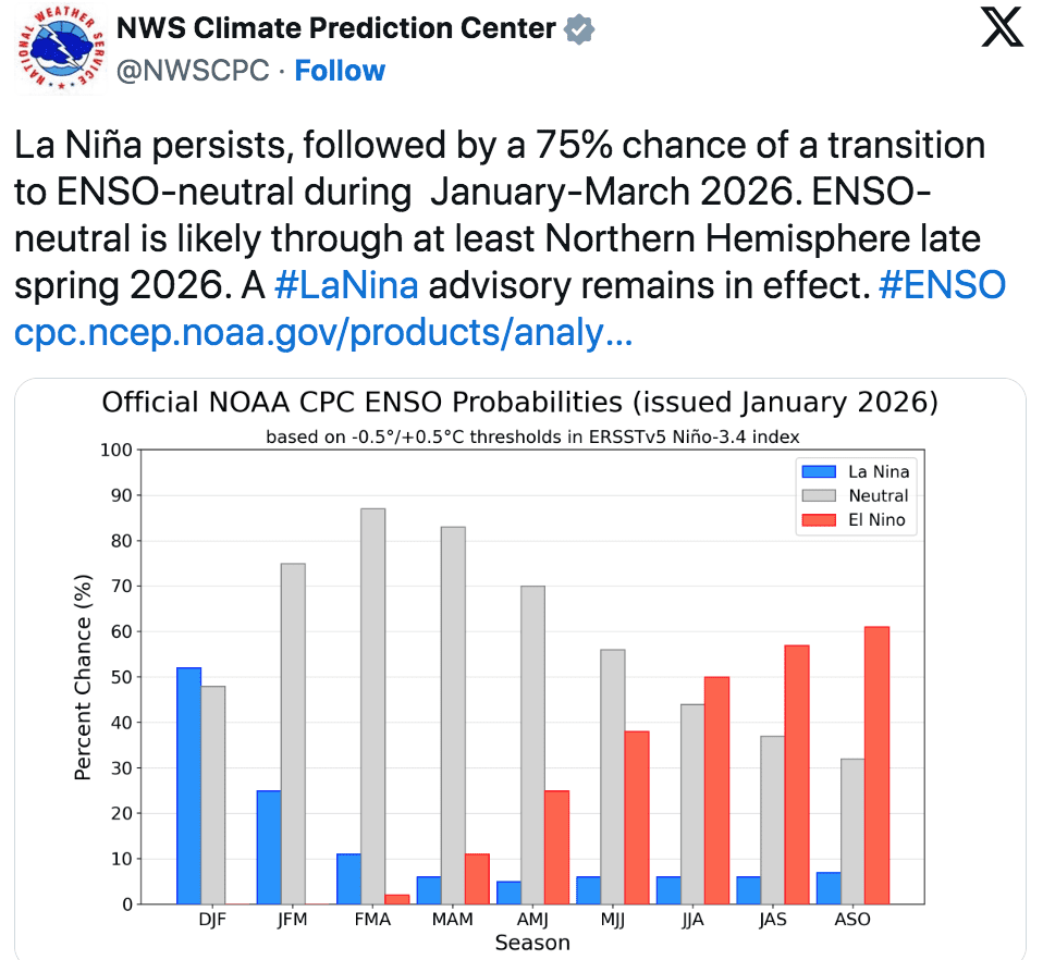
“La Niña persists, followed by a 75% chance of a transition to an El Niño Southern Oscillation (ENSO)-neutral phase during January-March 2026,” NOAA stated. “ENSO-neutral is likely in the Northern Hemisphere in late spring 2026. A La Niña advisory remains in effect.”
In the U.S. Virgin Islands and Puerto Rico, hurricane season runs from June 1 through Nov. 30. The question isn’t just if El Niño could develop, but when – and whether it would be strong enough to matter during peak months.

ENSO Explained
“Scientists call the two opposing climate patterns of El Niño and La Niña the ‛El Niño-Southern Oscillation’ cycle. El Niño and La Niña can both have global impacts on weather, wildfires, ecosystems, and economies,” according to NOAA.
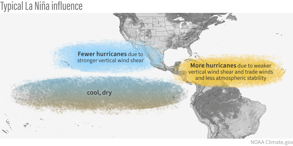
During a La Niña cycle, the ocean waters across the equatorial Pacific Ocean cool significantly, affecting global weather. During La Niña, wind shear—a change in wind direction and velocity with height in the atmosphere—also typically decreases in the Atlantic Ocean. A reduction in wind shear can favor cyclone development. This pattern is the opposite of “El Niño,” a warming of the equatorial Pacific, which usually increases wind shear in the Atlantic Ocean, helping to rip apart storms and prevent hurricane formation and intensification.
ENSO-neutral typically occurs in between phases of a La Niña or an El Niño event.
A Forecaster’s Perspective
The Source contacted Alex DaSilva, lead hurricane expert at AccuWeather, to discuss what he’s observing and what it could mean for the Caribbean as the 2026 season approaches. DaSilva said one of the main things he’s watching is what’s happening beneath the ocean surface in the eastern Pacific.
“We are currently in a La Niña pattern, but subsurface water temperatures in the eastern Pacific are warming very rapidly,” DaSilva explained. “Even though surface waters remain cooler, that warm water below the surface suggests La Niña could break down quickly, with a transition toward El Niño possible later this spring or early summer. There is often a lag between changes in ocean temperatures and how the atmosphere responds. How long that lag lasts could have important implications for the early part of the Atlantic hurricane season,” he continued.
Possible Strength of an El Niño in 2026
DaSilva said AccuWeather expects El Niño to develop, most likely reaching moderate strength during the hurricane season, with the possibility it could become stronger.
“At this point, we do expect El Niño to develop and become at least moderate during the hurricane season,” DaSilva confirmed. “There is a chance it could become strong, but moderate is the most likely outcome right now. This appears to be shaping up as a more traditional El Niño, not an extremely strong pattern known as an ‘El Niño Modoki’ event,” he said.
Effects Across the Atlantic Basin
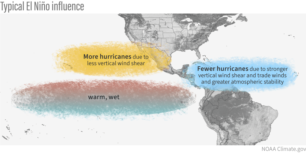
El Niño years often feature stronger upper-level winds over the tropical Atlantic, increasing vertical wind shear that can disrupt storm organization and intensification across the Atlantic basin.
A recent report about El Niño from Weather.com provided the following information: “El Niño typically means fewer Atlantic hurricanes because there is stronger wind shear present, making it more difficult for storms to develop.”
The National Weather Service similarly notes the Caribbean’s hurricane odds “increase substantially during La Niña and decrease during El Niño,” while also emphasizing that ENSO-neutral years can still produce significant events.
DaSilva said wind shear is the headline factor, but it’s not the only one he’ll be monitoring.
“Increased wind shear is usually the main suppressing factor during El Niño, but we also monitor jet stream placement, wind-flow and steering patterns, and overall atmospheric stability,” stated DaSilva. “Those details are still too early to pin down, but they will become clearer closer to the season. Stability in the tropical Atlantic has played a bigger role in recent years, especially across the main development region, and that is something we are watching closely again this year.”
However, it is important to note that even if an El Niño develops, unusually warm Atlantic waters can still support tropical activity, and DaSilva said that’s one reason it’s too early to assume a simple “quiet season” outcome.
“Sea surface temperatures in the Atlantic are a major wildcard,” DaSilva cautioned. “The tropical Atlantic looks poised to be warmer than average again, potentially similar to last year, which ranked among the warmest years on record. Warm Atlantic waters can partially offset the suppressing effects of El Niño, which is likely one of the reasons we still saw a high number of storms in 2023, when an El Niño was occurring. We are also closely watching conditions near the equator off Africa, as cooler waters in that location can suppress storm formation, while warmer waters can support increased activity,” he continued.
Clearer Picture Will Emerge in the Coming Months
DaSilva said timing may be everything, including the possibility that early-season conditions could support development even if the peak months become less favorable later.
“If the transition to El Niño is delayed or borderline, that could allow for early-season development in May or June,” DaSilva explained. “Later in the season, if El Niño strengthens, conditions could become less favorable during the peak months. That kind of split-season behavior is possible and something we will be monitoring closely,” he said.
DaSilva noted that a clearer signal about ENSO predictions often emerges during late winter and early spring.
“Confidence in the ENSO phase usually improves meaningfully in March and April, sometimes into May,” DaSilva stated. “January and February can be tricky, because computer models do not always handle ENSO transitions well during that time of year. Last year, the models performed well early on, but that is not always the case, which is why caution is important this far out,” he advised.
NOAA similarly emphasized that while El Niño chances increase at longer forecast horizons, uncertainty remains higher “given the lower accuracy of model forecasts through the spring.”
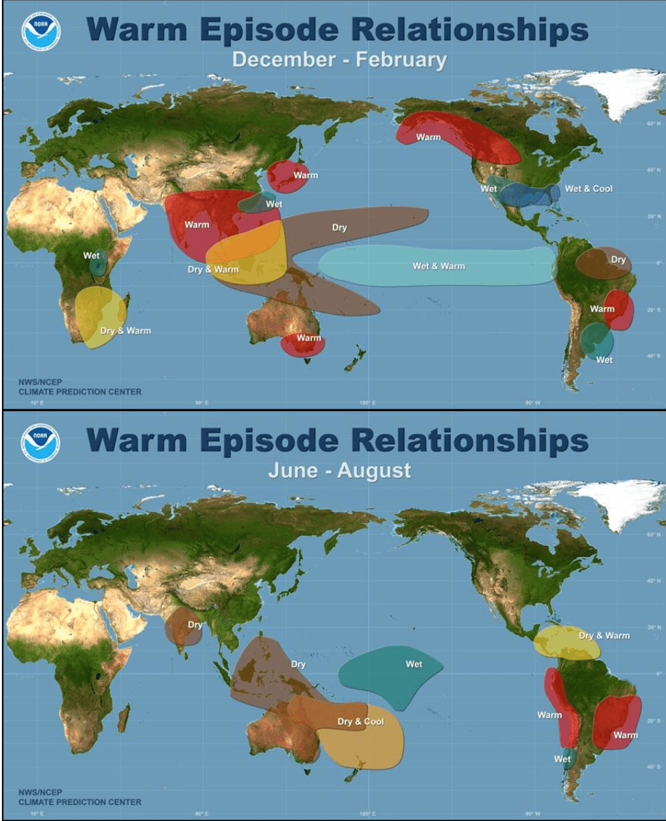
Notably, while ENSO is closely followed for hurricane season impacts, researchers continue to document its broader influence on global extremes. A recent Phys.org report on research using NASA satellite data said, “The researchers found that abnormal ENSO activity can push far-flung regions simultaneously into dry or wet conditions.”
Similar Years Based on Climatology
DaSilva said that AccuWeather is looking at several years that are similar to 2026 for clues, while stressing that it’s still too early to draw firm conclusions.
“Some analog years we are examining include 2023, 2014, and 1997,” DaSilva reported. “Most El Niño years tend to be less active, but 2023 showed that high storm counts are still possible under the right conditions. The key message right now is that it is too early for certainty. AccuWeather’s official forecast, which will be released in March, will incorporate more data and allow us to be more specific about risks, but early signals show this season may not follow a simple textbook pattern.”
Stay Informed
The Atlantic hurricane season runs from June 1 through Nov. 30, but severe weather preparedness is a year-round practice in the Virgin Islands. Residents can follow NOAA’s Climate Prediction Center for ENSO updates, and the local weather forecast for the U.S. Virgin Islands is regularly updated on the Source Weather Page and VI Source YouTube Channel. Individuals can also find helpful weather information, emergency preparedness, and alerts from the Virgin Islands Territorial Emergency Management Agency.


