
The National Weather Service in San Juan, Puerto Rico, expects gusty winds, hazardous seas, and elevated rip current risks for the U.S. Virgin Islands and Puerto Rico through the weekend and into early next week, with periods of passing showers possible.
According to the NWS, winds are forecast to strengthen on Friday and continue into the weekend due in part to a building area of high pressure situated over the Atlantic. These stronger winds, along with the arrival of a long-period, northerly swell, will contribute to choppy to rough marine conditions across the local waters.
Gusty Winds and Possible Precipitation
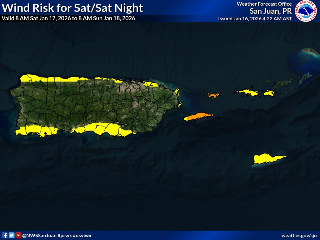
“Variable and breezy conditions will persist in the short-term forecast,” according to an update from the NWS on Friday afternoon. “A surface high pressure over the central Atlantic will strengthen, increasing the pressure gradient and bringing breezy to windy conditions across the islands. Hence, coastal areas and higher elevations can expect higher wind gusts this weekend between 26 and 38 mph,” the NWS reported.

Forecasters with the NWS advised individuals across the region to secure outdoor objects and to use caution due to the potential for strong winds across the area. In addition to gusty winds, the NWS said that there will be a possibility of intermittent rainfall and thunderstorms.
“From Saturday night through Sunday, a trade wind-driven pattern persists with fresh to locally strong winds and passing showers, while conditions become more stable by Sunday afternoon,” the NWS said. “Overall hazards include localized ponding and minor flooding mainly Saturday across northeastern and western Puerto Rico and increasing wind impacts beginning Friday night and persisting through the weekend, especially across exposed and coastal areas.”
Hazardous Marine Conditions
Gusty winds blowing across the islands will churn up seas, and an approaching long-period, northerly swell is forecast to further deteriorate marine conditions. The period of a swell refers to the time between breaking waves.
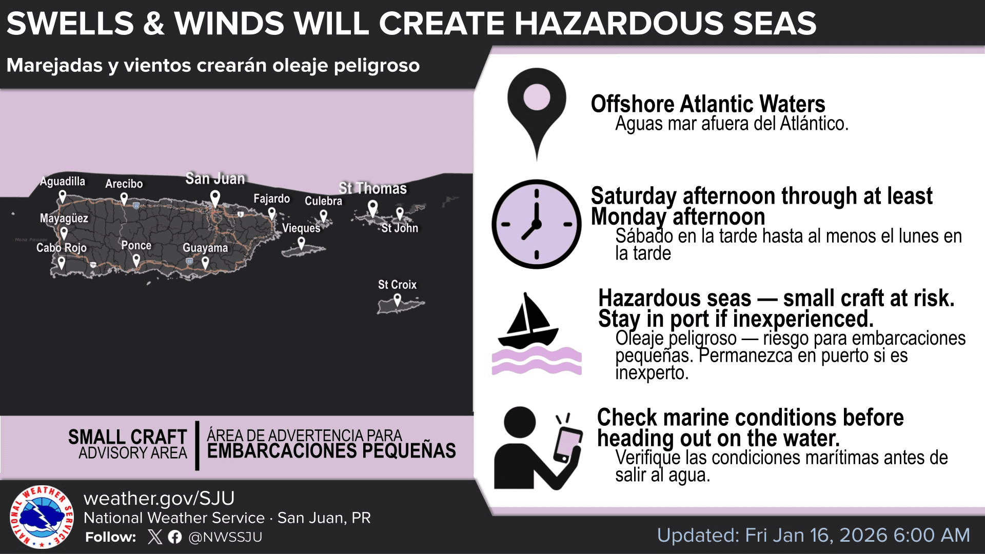
The NWS has noted that a Small Craft Advisory has been issued for portions of the waters surrounding the local region, and the alert will go into effect on Saturday. Additional alerts could be issued over the weekend.
“On Saturday, strengthening east to northeast winds and the arrival of a long-period northerly swell will likely result in choppy to rough seas, leading to hazardous marine conditions during the weekend into the upcoming workweek,” the NWS warned.
“A Small Craft Advisory will be in effect for the offshore Atlantic waters from late Saturday into Monday. Mariners are urged to exercise caution across the offshore Atlantic waters and the local passages as we head into the weekend,” the NWS added.
Elevated Risk of Rip Currents
Beachgoers should be aware of elevated to high rip current risks, especially along north- and northeast-facing and exposed beaches. A high risk of rip currents is anticipated for the weekend as northerly swell energy and wind speeds increase.
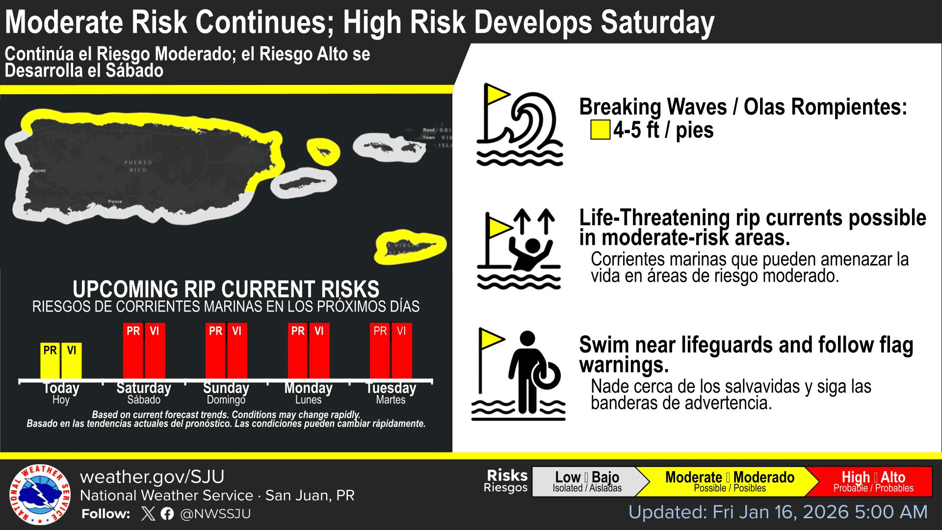
“Computer forecast model guidance continues to suggest a northerly swell moving into the local waters, combining with rough seas generated by breezy conditions,” the NWS said. “This pattern will lead to increasingly large breaking waves and stronger nearshore currents, particularly along the north and northeast-facing beaches of Puerto Rico, including Culebra, as well as exposed beaches across the U.S. Virgin Islands,” the NWS cautioned.
“As a result, a high risk of rip currents is expected to develop on Saturday and continue through the weekend, posing hazardous conditions for swimmers and beachgoers.”
Regarding rip current safety, the National Oceanic and Atmospheric Administration offers the following tips.
“If caught in a rip current, know your options:
- Relax; rip currents don’t pull you under.
- Don’t swim against the current.
- You may be able to escape by swimming out of the current in a direction following the shoreline or toward breaking waves, then at an angle toward the beach.
- You may be able to escape by floating or treading water if the current circulates back toward shore.
- If you feel you will be unable to reach shore, draw attention to yourself. If you need help, yell and wave for assistance.”
Additional advice on rip current safety is available on NOAA’s website.
Watching the Weather
Local weather information, including marine weather conditions, is available from the NWS, the NHC, and the National Oceanic and Atmospheric Administration.
Additionally, the local weather forecast for the U.S. Virgin Islands is regularly updated on the Source Weather Page and VI Source YouTube Channel. Residents and visitors can find additional weather alerts and preparedness information from the Virgin Islands Territorial Emergency Management Agency.


