
Hazardous surf and rip currents from a powerful swell will affect Puerto Rico and the U.S. Virgin Islands through early next week, prompting marine alerts. Meanwhile, the National Hurricane Center is monitoring two Atlantic disturbances, one of which could potentially threaten the Caribbean next week if it develops.
Powerful Swell to Affect USVI and Puerto Rico
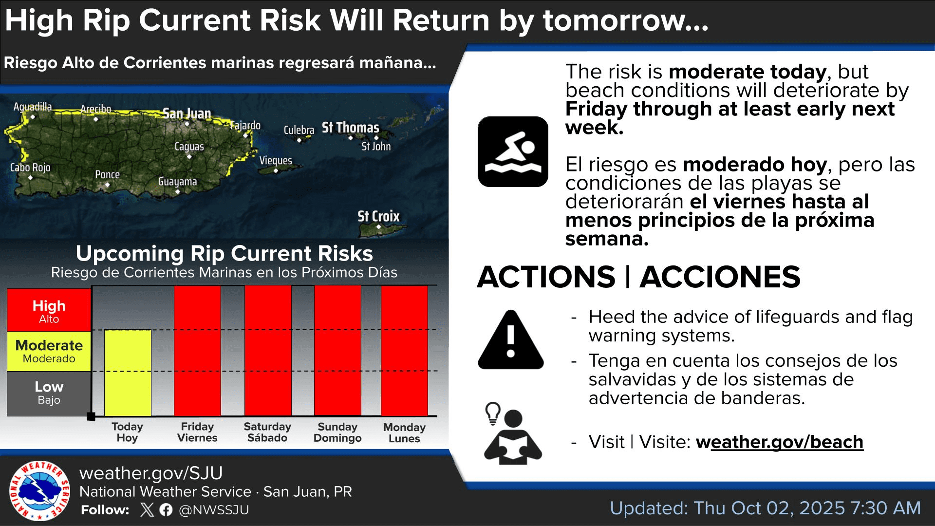
The National Weather Service in San Juan, Puerto Rico, has warned that a long-period swell will bring hazardous seas across the U.S. Virgin Islands and Puerto Rico beginning Thursday night and continuing into early next week.
The swell is being generated by Post-Tropical Cyclone Imelda and the remnants of Hurricane Humberto, both located well to the north of the region. Dangerous waves tied to these systems have already impacted Bermuda and parts of the U.S. East Coast, including North Carolina’s Outer Banks, where multiple homes were destroyed by rough surf conditions.

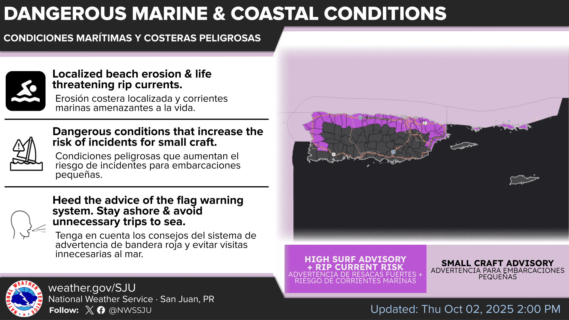
“A long-period swell will arrive late Thursday night, bringing hazardous beach conditions through at least early next week,” the NWS warned on Thursday. “Life-threatening rip currents are expected along the north-facing beaches of Puerto Rico, including Vieques and Culebra, and the northern U.S. Virgin Islands, spreading over west-facing beaches of Puerto Rico and St. Croix in the U.S. Virgin Islands during the weekend. Additionally, the potential of High Surf conditions is increasing due to high chance of breaking waves above 10 feet,” the NWS continued.
Several marine alerts have already been issued for portions of Puerto Rico and the northern U.S. Virgin Islands, including a Small Craft Advisory, a High Rip Current Risk, and a High Surf Advisory. These alerts remain in effect through at least early next week. The NWS added that additional advisories may be issued in the coming days, possibly including St. Croix.
“If you become caught in a rip current, yell for help,” the NWS advised. “Remain calm, do not exhaust yourself and stay afloat while waiting for help. If you have to swim out of a rip current, swim parallel to shore and back toward the beach when possible. Do not attempt to swim directly against a rip current as you will tire quickly.”
On Thursday morning, the Source spoke with Yidiana Zayas-Rivera, a meteorologist at the National Weather Service, about the incoming swell. She confirmed that breaking waves could reach up to 10 to 13 feet along northern Puerto Rico and the northern U.S. Virgin Islands.
Zayas-Rivera added that hot weather will persist across the islands, meaning additional heat alerts may be issued. The NWS also noted that a weak tropical wave is forecast to cross the Caribbean over the weekend, bringing an increased risk of showers and thunderstorms.
Tropical Disturbances Monitored by NHC
The NHC is monitoring several disturbances across the Atlantic basin, including the remnants of Post-Tropical Cyclone Imelda, which passed just south of Bermuda Wednesday night as a Category 2 hurricane.
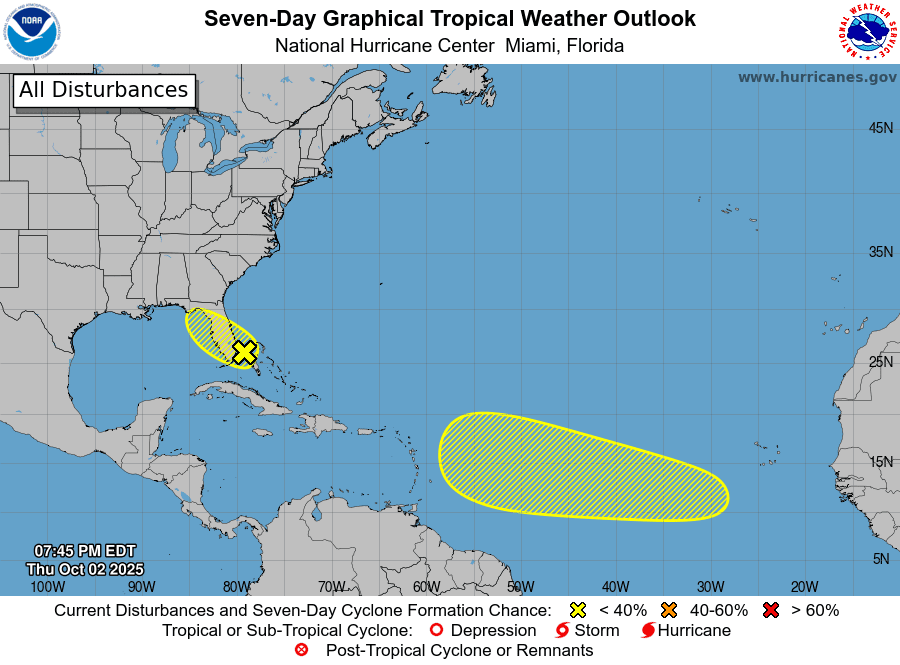
Forecasters are also watching two additional systems: Disturbance #2 in the Eastern Atlantic and Disturbance #1, an area of low pressure near the northwestern Bahamas and southern Florida. As of Thursday afternoon, both carried only a low chance of development over the next seven days.
For residents and visitors in Puerto Rico and the U.S. Virgin Islands, Disturbance #2 is worth monitoring, as some forecast models suggest a storm could develop in the Main Development Region and move closer to the Caribbean during the second half of next week. Forecast confidence, however, remains low.
The NWS emphasized that while the situation bears monitoring, significant uncertainty remains.
“The NHC is monitoring a tropical wave expected to move off the coast of Africa in the next few days, with a 20% chance of cyclonic formation in the next 7 days,” the NWS reported. “The latest model solutions suggest an increase in moisture content due to this tropical wave approaching the Caribbean Basin by late Thursday night, but the variability between them is high, introducing uncertainty to the forecast. Hence, we will keep monitoring the development of this system.”
Watching the Weather
It is crucial to remember that the forecast can change very quickly. USVI residents and visitors are encouraged to continue to remain prepared. Weather information is available from the NWS, the NHC, and the National Oceanic and Atmospheric Administration.
Additionally, the local weather forecast for the U.S. Virgin Islands is regularly updated on the Source Weather Page and VI Source YouTube Channel. A weekly Tropical Outlook article from the Source is also published throughout hurricane season to provide in-depth updates. Residents and visitors can find additional weather alerts and preparedness information from the Virgin Islands Territorial Emergency Management Agency.


