
The National Hurricane Center is monitoring newly formed Tropical Storm Jerry across the Atlantic. Forecasters say the storm could approach or pass very near the Northern Leeward Islands late this week, bringing the potential for gusty winds and rainfall. Residents across the region are urged to follow official forecasts closely.
Tropical Storm Jerry
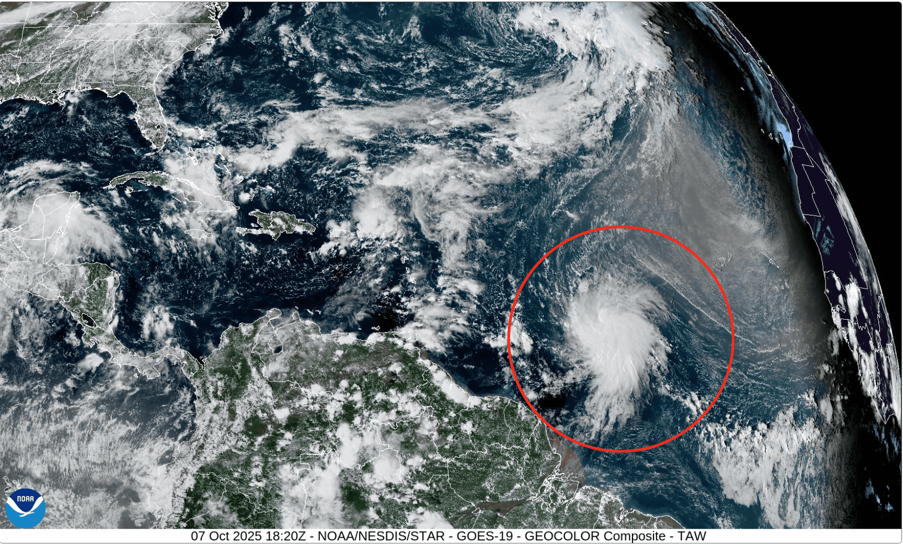
The NHC had been tracking Invest 95L for several days before upgrading the disturbance to a tropical storm Tuesday afternoon. Now named Jerry, it is the 10th named cyclone of the 2025 Atlantic hurricane season, and forecasters expect it to strengthen into a hurricane within the next few days.
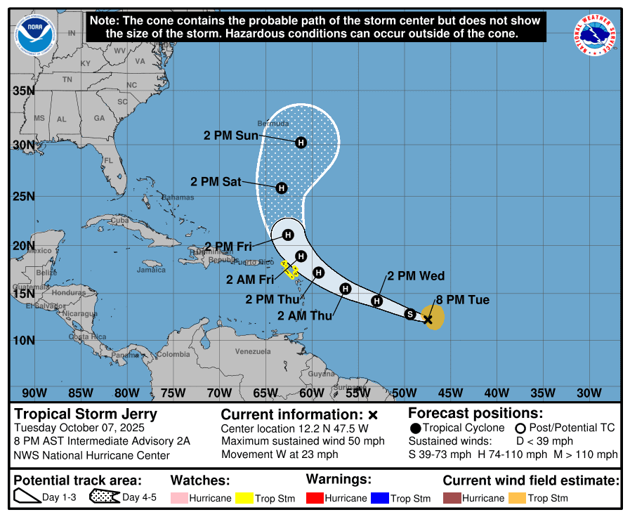
As of Tuesday evening, the cyclone was located about 1120 miles east-southeast of the Northern Leeward Islands, traveling quickly westward, and packing winds of approximately 50 mph. Jerry is forecast to continue strengthening as it travels toward the Caribbean.

Official Forecasts from the National Hurricane Center
“At 8:00 p.m. AST, the center of Tropical Storm Jerry was located near latitude 12.2 North, longitude 47.5 West. Jerry is moving toward the west near 23 mph,” according to an update from the NWS on Tuesday evening.
“A decrease in forward speed and a turn to the west-northwest is expected during the next couple of days. On the forecast track, the core of the system is expected to be near or to the north of the Northern Leeward Islands late Thursday and Friday.
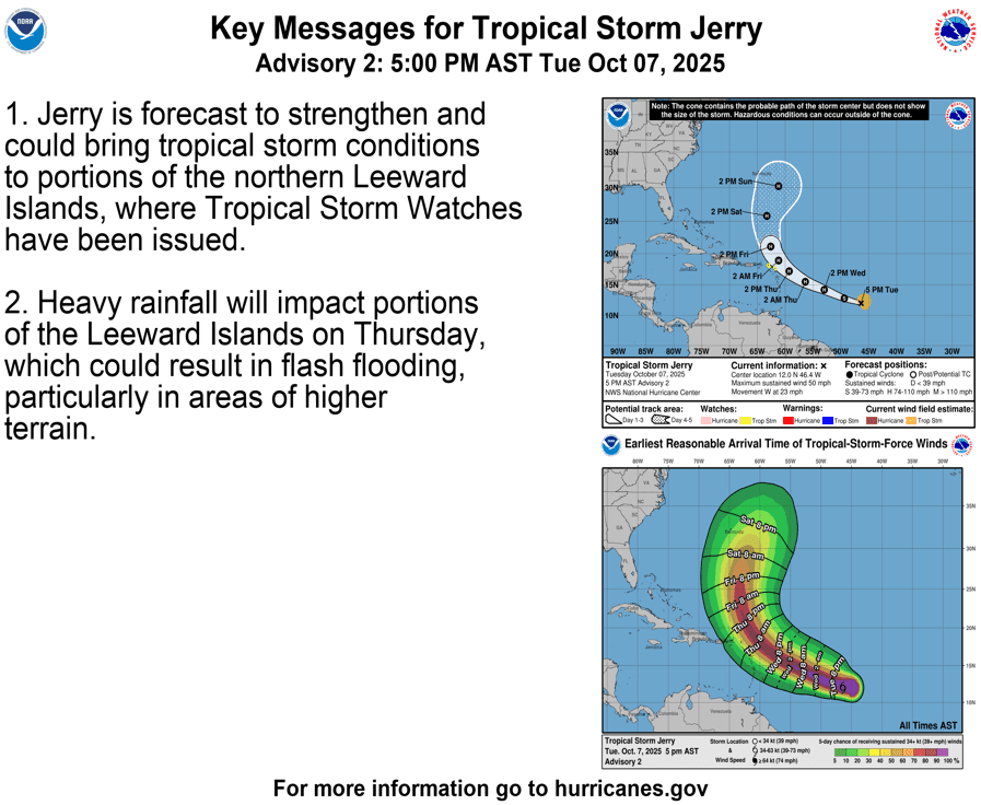
“Maximum sustained winds are near 50 mph with higher gusts. Steady strengthening is forecast, and Jerry is expected to become a hurricane in a day or so. Tropical-storm-force winds extend outward up to 140 miles from the center, and the estimated minimum central pressure is 1003 millibars,” the NHC explained.
Due to the potential for the system to pass very close to several Caribbean islands, a tropical storm watch has been issued for Antigua, Barbuda, and Anguilla, St. Kitts, Nevis, and Montserrat, St. Barthelemy and St. Martin, and Sint Maarten, Guadeloupe and the adjacent islands, and Saba and St. Eustatius. As of Tuesday evening, no tropical weather alerts have been issued for the U.S. Virgin Islands or Puerto Rico.
“Interests elsewhere in the Northern Leeward Islands and the British and U.S. Virgin Islands should monitor the progress of Jerry,” the NHC advised.
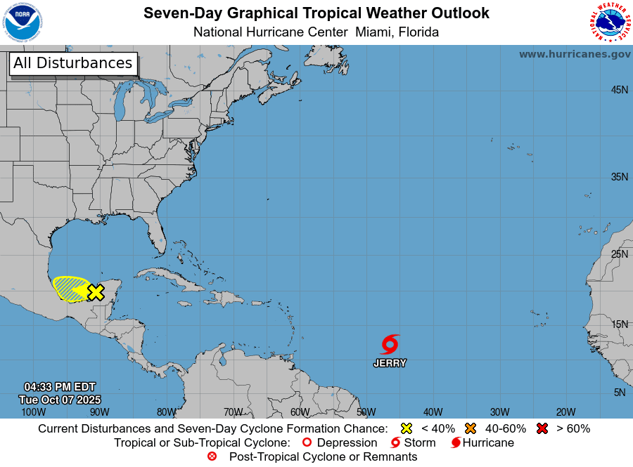
In addition to Tropical Storm Jerry, a low-pressure area over the Southwestern Gulf is being monitored for possible development, though it currently has only a low chance of intensification. A separate system could also bring severe weather to portions of the U.S. East Coast later this week.
Hurricane Expert Insight
On Tuesday morning, AccuWeather released information about Tropical Storm Jerry, noting that while the storm is expected to turn northward and away from the U.S. Virgin Islands and Puerto Rico, the track could still change, and residents across the Caribbean islands should remain alert.
“The cyclone will begin to turn northward as it approaches the northern Lesser Antilles, where it could bring some heavy rain and gusty winds as it passes Thursday into Friday,” according to AccuWeather. “Interests in the Lesser Antilles and Puerto Rico should monitor the progress of this storm, as a shift in the track could bring stronger impacts. This system is then expected to intensify into a hurricane as well, before losing wind intensity and moving into the open Atlantic.”
The Source reached out to Alex DaSilva, AccuWeather’s lead hurricane expert, to learn more about Tropical Storm Jerry, as well as any other potential tropical weather threats in the coming days.
“Jerry is being guided westward by the Bermuda High, and there’s a weakness developing on the western side of that ridge of high pressure, which should allow the storm to turn toward the north,” DaSilva said. “In addition, a dip in the jet stream across the East Coast will help steer Jerry out to sea and away from the United States. That said, the system could come close enough to the Northern Leeward Islands to bring some impacts Thursday into Friday, and if the storm tracks a bit farther west than currently forecast, those impacts could increase,” DaSilva noted.
“Overall, we expect the northward turn to occur sometime Thursday afternoon or Friday as the system approaches the islands,” he added.
DaSilva explained that the cyclone has been battling disruptive wind shear, which could potentially help keep the storm from undergoing rapid intensification.
“Jerry has been dealing with some wind shear, and that will likely continue for the next couple of days, and because of that, we expect gradual intensification, not rapid strengthening,” DaSilva stated. “We expect Jerry to reach hurricane strength as it nears the islands.”
“The storm could strengthen into a Category 2 hurricane, with a low but not impossible chance of briefly reaching Category 3 status if wind shear subsides at the right time, but a Category 4 or 5 outcome appears very unlikely,” DaSilva said. “At this stage, a strong Category 1 or low-end Category 2 hurricane is the most reasonable expectation as Jerry approaches the Northern Leeward Islands,” DaSilva reported.
Potential Impacts for the Virgin Islands and Puerto Rico
On Tuesday evening, the NHC said that many computer models agree that the center of Tropical Storm Jerry will pass to the northeast of the Northeastern Leeward Islands. However, the agency cautioned that some models show the storm tracking closer to the islands, and residents are urged to remain vigilant.
“The best-performing models show the core of Jerry missing the Northern Leeward Islands. However, there are some forecast models that show the core of Jerry passing very near or over the islands. Therefore, interests there and in the Virgin Islands should monitor the system’s progress as details in the forward speed of the storm and strength of the ridge will be the main factors determining how close Jerry gets to the islands,” the NHC said.
DaSilva also noted that even if the core of the cyclone remains over water, some impacts could be felt across the USVI and Puerto Rico.
“Most of the heavy rain and strong winds should remain east of the U.S. Virgin Islands and Puerto Rico, focused more across areas located farther east in the Northern Leeward Islands,” DaSilva said. “If the current track holds, the U.S. Virgin Islands may see around one inch of rain, with gusts between 30 to 40 mph. The predicted 40 to 60 mph wind field is currently just east of the islands, but a slight westward shift in the track could bring stronger winds and heavier rainfall.
“Marine conditions will be quite rough, with large waves and strong rip currents developing later this week as Jerry passes the region,” DaSilva emphasized.
“Puerto Rico is likely to see fewer impacts than the U.S. Virgin Islands, given its position farther west,” DaSilva predicted. “The worst conditions are expected Thursday night into Friday, mainly in outer rainbands that could bring periods of gusty winds and brief downpours.
“However, if a northward turn happens later than forecast, both the timing and intensity of impacts could increase. We’ll have greater confidence in that aspect of the forecast within the next 24 to 36 hours,” he acknowledged.
National Weather Service Monitoring Tropical Storm Jerry
The National Weather Service in San Juan, Puerto Rico, is closely watching Tropical Storm Jerry, warning that the track of the storm remains uncertain. While the official track from the NHC shows Jerry passing to the north of the USVI and Puerto Rico, any wobbles or shifts in the storm path could significantly affect weather conditions across the local islands.
At the very least, forecasters at the National Weather Service expect periods of rain, gusty winds, and rough seas associated with the system to affect the local islands by the end of the week. The agency urged residents and visitors across the U.S. Virgin Islands and Puerto Rico to stay alert and monitor official updates closely.
“The forecast places Jerry as a hurricane located about 200 to 250 miles northeast of the U.S. Virgin Islands, Vieques, Culebra, and Northeastern Puerto Rico by late Thursday into early Friday,” the NWS said on Tuesday. “However, uncertainty remains regarding its track and intensity forecast. Residents and visitors should remain informed and monitor official updates from the National Hurricane Center and our local office as Jerry approaches the Caribbean basin,” the NWS advised.
Possible Cyclonic Development in October
The Atlantic hurricane season continues for about two more months, officially ending November 30. DaSilva noted that there is still time for tropical development to occur, including systems that could organize and potentially affect the local islands. However, based on climatology, the risk of tropical cyclone impacts across the Northeastern Caribbean typically decreases after mid-October.
Still, he advised individuals across the Caribbean to keep an eye on a tropical wave that is forecast to emerge off Africa this week for possible organization.
“We’re monitoring another tropical wave emerging off Africa later this week that could organize as it moves westward,” DaSilva stated. “Some forecast models have begun to hint at potential development, and it’s possible we could officially begin highlighting that system within the next day or so. That said, we’re nearing the time of year when tropical activity in the U.S. Virgin Islands and Puerto Rico typically starts to wind down. After about Oct. 15 to 20, the likelihood of additional tropical impacts in that region drops significantly,” DaSilva noted.
“Therefore, while another system or two could still develop in the Atlantic, the odds of one affecting the islands will decrease sharply later this month,” he concluded.
NOAA Global Tropics Hazards Outlook
According to a Global Tropics Hazards Outlook released Tuesday, there will continue to be an elevated chance of cyclonic development across portions of the Atlantic basin in the coming weeks. The forecast tool, which is issued every Tuesday by NOAA’s Climate Prediction Center, provides insight into potential activity across tropical basins up to three weeks in advance.
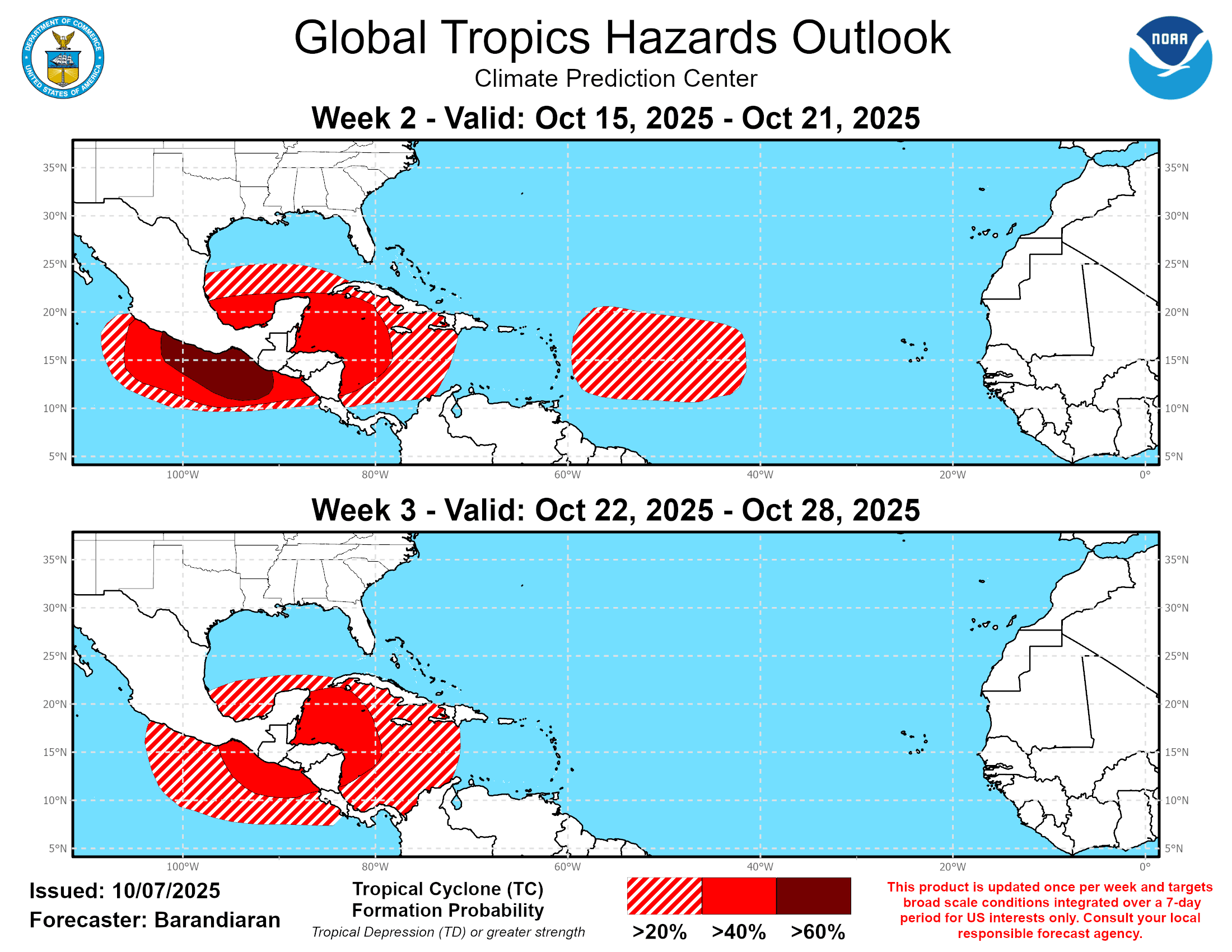
In its latest update, NOAA said that areas across a portion of the Main Development Region of the Atlantic basin — the zone between the west coast of Africa and the Caribbean — may experience a 20-40% chance of tropical development during the “Week Two” outlook period, which runs from Oct. 15 until Oct. 21. Development is not forecast across the Main Development Region in the “Week Three” outlook, running from Oct. 22 through Oct. 28.
However, according to the forecast, areas across the western Caribbean Sea and the Gulf are likely to see an elevated chance of tropical cyclogenesis at times in October.
Additionally, the Eastern Pacific basin, which remains active, is also expected to experience an increased risk for cyclonic development in the coming weeks.
Local Weather Information and Staying Informed
Finally, the NWS has reminded residents and visitors of ongoing weather-related threats across Puerto Rico and the U.S. Virgin Islands, including the potential for showers and thunderstorms as a weak tropical wave moves through the area through Wednesday. Very warm temperatures could also prompt continued heat alerts, while marine conditions are expected to remain hazardous due to a fading northeasterly swell.
The forecast can change very quickly, and USVI residents and visitors are encouraged to continue to remain prepared. Weather information is available from the NWS, the NHC, and NOAA.
The local weather forecast for the U.S. Virgin Islands is also regularly updated on the Source Weather Page and VI Source YouTube Channel. Additionally, A weekly Tropical Outlook article from the Source will be published throughout hurricane season to provide in-depth updates.
Residents and visitors can find additional weather alerts and preparedness information from the Virgin Islands Territorial Emergency Management Agency.


