
Updated: June 30 | 5 p.m. NHC Advisory
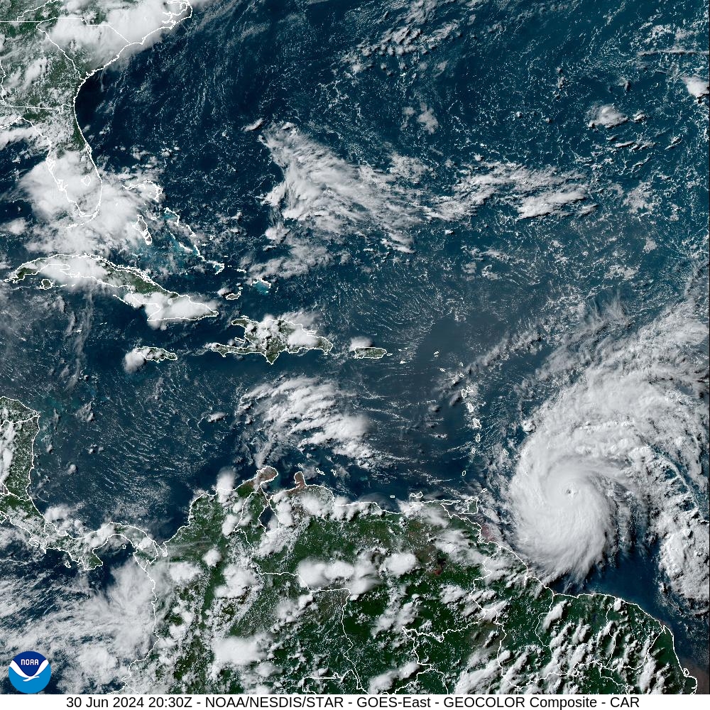
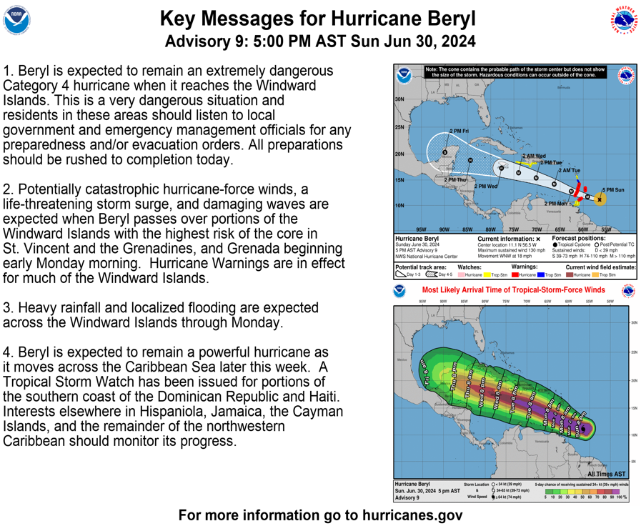
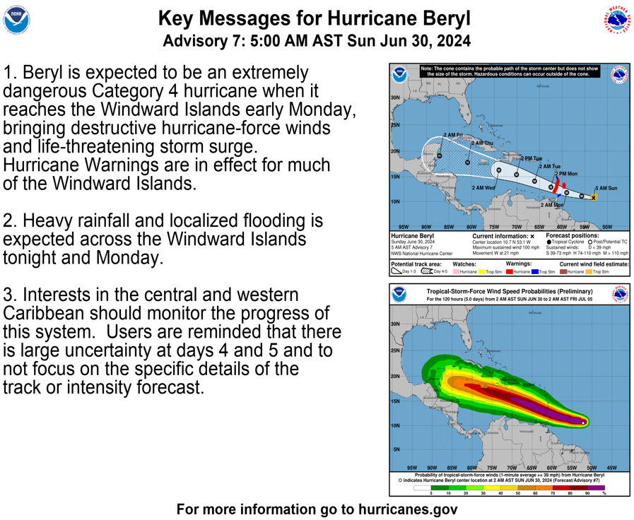
A 5:00 p.m. update from the National Hurricane Center on Sunday explained that Hurricane Beryl has intensified into a major Category 4 hurricane. Beryl is moving toward the west-northwest at approximately 18 mph, with maximum sustained winds of about 130 mph. The powerful cyclone is anticipated to pass across the southern Lesser Antilles on Monday.
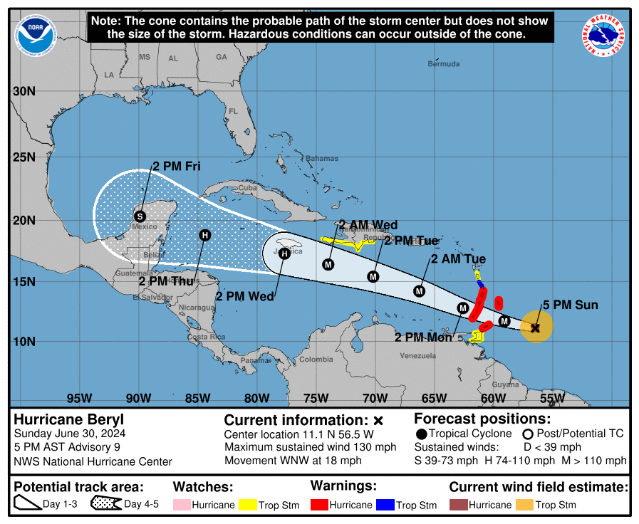
“Beryl is expected to remain an extremely dangerous Category 4 hurricane when it reaches the Windward Islands,” according to the NHC. “This is a very dangerous situation, and residents in these areas should listen to local government and emergency management officials for any preparedness and/or evacuation orders, [and] all preparations should be rushed to completion today,” the NWS continued.
Hurricane Beryl has already broken several historical weather records. “The storm is rewriting hurricane history. Its early formation, rapid intensification, and location are all record-breaking,” according to information obtained from an article in Axios on Sunday.

The NHC provided the following information regarding tropical alerts that are currently in effect:
“A Hurricane Warning is in effect for Barbados, St. Lucia, St. Vincent and the Grenadine Islands, Grenada, and Tobago. A Tropical Storm Warning is in effect for Martinique, and a Tropical Storm Watch is in effect for Dominica, Trinidad, and portions of the Dominican Republic and Haiti.”
Areas under severe weather advisories can expect very high winds, choppy seas, rough surf, heavy rainfall, and a hazardous storm surge. The NHC reminded individuals across the Caribbean to watch the system closely.
“Interests elsewhere in the Lesser Antilles, Hispaniola, Jamaica, the Cayman Islands, and the remainder of the northwestern Caribbean should closely monitor the progress of Beryl,” the NHC advised. “Additional watches or warnings may be required tonight or on Monday.”
Beryl’s Projected Storm Track and Potential Impacts Across USVI, Puerto Rico
The NHC noted that Hurricane Beryl is forecast to pass a couple of hundred miles south of the U.S. Virgin Islands and Puerto Rico, and as of 5 p.m. on Sunday, no watches or warnings are in effect for either U.S. territory.
However, as mentioned during an earlier Source weather update, regardless of the cyclone’s proximity to the local islands, some impacts from the hurricane are likely across the local region. Regarding potential storm impacts to the USVI and Puerto Rico, the National Weather Service in San Juan, Puerto Rico, provided the following information on Sunday afternoon:
“An increase [in] wind speeds and passing showers will focus heavy rainfall at times across the southern to eastern half of Puerto Rico, including the USVI, as Beryl moves well south of the region [around Monday night and through Tuesday],” the NWS said. “[The cyclone is] currently projected to be over 200 miles south of islands by Tuesday morning, [and] squally weather is possible, [which] could bring impressive thunderstorm activity that could cause flooding and wind impacts. This pattern will last through Tuesday evening as the system moves westward further away from the area,” the NWS continued.
Choppy seas and high wave heights, potentially reaching up to 10 feet, are also forecast to impact the region as the system moves past the area.
“Swells from Beryl will create life-threatening rip currents along the south-facing beaches of Puerto Rico and the U.S. Virgin Islands from Monday afternoon onward,” the NWS warned.
NHC Watching Additional Tropical Waves
In addition to Hurricane Beryl, the NWS has reminded residents and visitors about a second tropical wave behind Beryl, “Invest 96L.” This wave is moving across the Atlantic and will continue to be monitored for potential impacts on the local islands later this week. (An “invest” is an area under investigation for tropical development.)
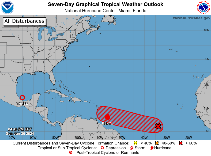
“The NHC is currently monitoring an area of low pressure located over the eastern Atlantic with a medium-to-high formation chance over the next seven days,” the NWS said. “Latest model guidance suggests that this system will develop as a tropical cyclone before reaching the Lesser Antilles.”
“Nonetheless, this system should remain south of the islands and over the Caribbean waters,” the NWS noted. “At this moment, some of the potential indirect impacts [to the USVI and Puerto Rico] associated [with] this low-pressure system [may include] localized flooding, gusty winds, squally weather, and deteriorated marine and coastal conditions.”, the NWS continued. “It is too early at this moment to determine the amount of expected rain.”
Finally, the NHC is also monitoring a disturbance near the southwestern Gulf of Mexico, which was recently upgraded to “Tropical Depression Three.” The storm is expected to make landfall on Monday morning across the east coast of Mexico.
Severe Weather Updates
The weather forecast and cyclone track can change quickly. USVI residents and visitors are encouraged to closely follow Hurricane Beryl and additional tropical disturbances.
Information regarding hurricane preparedness from the Virgin Islands Territorial Emergency Management Agency and the National Oceanic and Atmospheric Administration.
Weather forecast information, including severe weather alerts, is available from the VITEMA website and the National Weather Service. The Source Weather Page also publishes a daily weather forecast and offers readers the opportunity to view weather forecast videos and disaster preparedness video segments.
Updated: June 30 | 8 a.m. NHC Advisory
An 8:00 a.m. AST update from the National Hurricane Center on Sunday explained that Hurricane Beryl has intensified into a major category-three hurricane. The cyclone is moving toward the west at approximately 21 mph, with maximum sustained winds of about 115 mph. The system is anticipated to strengthen further as it passes across the southern Lesser Antilles early Monday and into Tuesday.
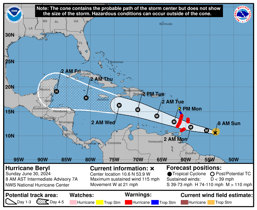
“A continued quick westward to west-northwestward motion is expected during the next few days,” the NHC said. “On the forecast track, the center of Beryl is expected to move across the Windward Islands early on Monday and across the southeastern Caribbean Sea Monday night and Tuesday,” the NHC continued.
“Continued rapid strengthening is forecast over the next day or so, and Beryl is expected to become an extremely dangerous category-four hurricane before it reaches the Windward Islands,” the NHC warned.
The NHC provided the following information regarding tropical alerts that are currently in effect:
“A Hurricane Warning is in effect for Barbados, St. Lucia, St. Vincent and the Grenadine Islands, Grenada, and Tobago. A Tropical Storm Warning is in effect for Martinique, and a Tropical Storm Watch is in effect for Dominica.”
Beryl’s impact on this region of the Lesser Antilles will be significant, including high winds, choppy seas, heavy rainfall, and a hazardous storm surge.
Beryl Expected to Pass South of USVI, Puerto Rico
The NHC noted that Hurricane Beryl is anticipated to pass a couple of hundred miles south of the U.S. Virgin Islands and Puerto Rico, and no watches or warnings are currently in effect for either U.S. territory.
However, regardless of the cyclone’s proximity to the local islands, some impacts from the hurricane are likely. Regarding potential storm impacts to the USVI and Puerto Rico, the National Weather Service in San Juan, Puerto Rico, provided the following information on Sunday morning:
“According to the latest National Hurricane Center track, the hurricane’s center is projected to move far to the south of the U.S. Virgin Islands (approximately 259 miles south of St. Croix, U.S. Virgin Islands, [and] around 230 miles south of Cabo Rojo, Puerto Rico,) late Monday night through Tuesday.”
“Regardless of Beryl’s forecast track, marine conditions will deteriorate across the Caribbean Waters and local Passages from Monday evening onwards,” the NWS stated. “Seas will likely be between 10 and 15 feet or more, especially across the Caribbean offshore waters. Winds could increase to 25 knots or more, with even stronger gusty winds, especially near thunderstorms,” the NWS added.
“Beryl’s outer bands could also move across the region, generating squally weather. These quick-moving rains could produce rainfall amounts between one and two inches, with higher amounts between two and four inches across the islands,” the NWS warned. “Strong gusty winds will remain possible.”
NHC is Monitoring Additional Tropical Waves
The NWS also reminded residents that a second tropical wave, “Invest 96L,” is moving across the Atlantic and will be monitored for potential impacts to the region later this week. (An “invest” is an area under investigation for tropical development.)
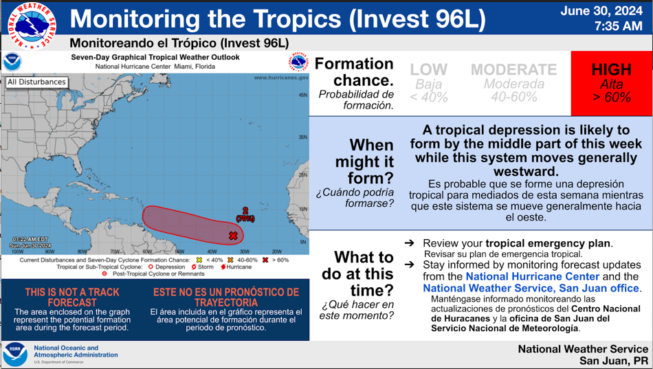
“Aside from Beryl, the NHC continues to monitor an area of low pressure (now designated as Invest 96L) [and is located] several hundred miles southwest of the Cabo Verde Islands [off of the west coast of Africa],” the NWS said.
“This system has a 70% chance of formation over the next seven days. Invest 96L could move close to the islands between late Wednesday night and Thursday,” the NWS continued.
Finally, the NHC is also watching “Invest 94L,” a disturbance near the southwestern Gulf of Mexico.
Weather Updates
It is extremely important to remember that the forecast and cyclone track can change quickly. USVI residents and visitors are encouraged to follow this system very closely.
Information regarding hurricane preparedness from the Virgin Islands Territorial Emergency Management Agency and the National Oceanic and Atmospheric Administration.
Weather forecast information, including severe weather alerts, is available from the VITEMA website and the National Weather Service. Additionally, the Source Weather Page also publishes a daily weather forecast and offers readers the opportunity to view weather forecast videos and disaster preparedness video segments.
June 29 | 7:15 p.m.
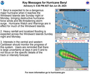
The National Hurricane Center has noted that tropical cyclone Beryl has intensified into a category one hurricane. The system is expected to strengthen into a major hurricane as it moves across portions of the southern Lesser Antilles on Sunday night and Monday.
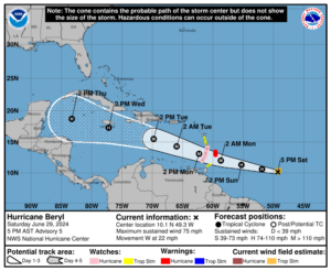
A 5:00 p.m. update from the NHC on Saturday explained that Hurricane Beryl is moving toward the west at approximately 22 mph, packing maximum sustained winds of about 75 mph, with higher wind gusts.
Multiple tropical weather alerts have been issued across the southern Lesser Antilles island chain. A Hurricane Warning is in effect for Barbados, and a Hurricane Watch is in effect for St. Lucia, St. Vincent and the Grenadines, and Grenada. A Tropical Storm Watch is in effect for Martinique, Dominica, and Tobago. Islands across this region are expected to experience impacts, including high wind, storm surge, rainfall, and rough seas.
The NHC provided the following details regarding the weather alerts:
“A Hurricane Warning means that hurricane conditions are expected somewhere within the warning area. A warning is typically issued 36 hours before the anticipated first occurrence of tropical storm-force winds, conditions that make outside preparations difficult or dangerous. Preparations to protect life and property should be rushed to completion.
A Hurricane Watch means that hurricane conditions are possible within the watch area. A watch is typically issued 48 hours before the anticipated first occurrence of tropical-storm-force winds, conditions that make outside preparations difficult or dangerous.
A Tropical Storm Watch means that tropical storm conditions are possible within the watch area, generally within 48 hours.”
Beryl Expected to Pass South of USVI, Puerto Rico
Hurricane Beryl is anticipated to pass approximately 200 miles south of the U.S. Virgin Islands and Puerto Rico, and no watches or warnings are currently in effect for either U.S. territory.
Regardless of the cyclone’s proximity to the local islands, some impacts from the hurricane are likely. Regarding potential storm impacts to the USVI and Puerto Rico, the National Weather Service in San Juan, Puerto Rico, provided the following information on Saturday afternoon:
“Thanks to strong high pressure across the Atlantic Ocean, Beryl will move westward across the Caribbean more than 200 miles south of Puerto Rico and the U.S. Virgin Islands between late Monday night and early Tuesday morning,” the NWS said.
Even with distance between the hurricane and the islands, marine conditions are forecast to become hazardous across the USVI and Puerto Rico as the hurricane moves past the region.
“Based on the latest guidance, Beryl will move [about 235 miles south] of Ponce, Puerto Rico, on Monday night and into Tuesday. There is a high confidence that marine conditions will deteriorate across the Caribbean Waters and the Mona and Anegada Passage,” the NWS stated.
“Expect marine conditions to slowly deteriorate from late this weekend onward due to the approaching Beryl and the next tropical wave arriving around the middle of the upcoming week,” the NWS continued.
In addition to choppy seas, rainfall and some gusty winds associated with Beryl are forecast to reach the USVI and Puerto Rico on Monday and Tuesday, and possibly into Wednesday.
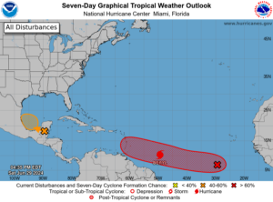
Additionally, a second tropical wave, which is traveling across the Atlantic behind Hurricane Beryl and is being monitored by the NHC, may also bring some impacts to both U.S. territories around Thursday. However, at this time, the second tropical wave is also expected to pass south of the local islands.
“Although an increase in moisture is expected next week, there is high uncertainty in terms of rainfall amounts at this time,” the NWS acknowledged.
The NHC is also watching “Invest 94L,” a disturbance near the southwestern Gulf of Mexico. (An “invest” is an area under investigation for tropical development.)
As reported in a recent Source article, a very active 2024 season is possible because of several factors, including a transition from an El Niño weather pattern to La Niña and extraordinarily warm sea surface temperatures across the North Atlantic. The combination of these elements may contribute to an increase in cyclones developing this year. Notably, the NHC explained that it is exceedingly rare for a cyclone to develop in the central or eastern Atlantic this early in the season.
Weather Updates
It is extremely important to remember that the forecast and cyclone track can change quickly. USVI residents and visitors are encouraged to follow this system very closely.
Information regarding hurricane preparedness from the Virgin Islands Territorial Emergency Management Agency and the National Oceanic and Atmospheric Administration.
Weather forecast information, including severe weather alerts, is available from the VITEMA website and the National Weather Service. Additionally, the Source Weather Page also publishes a daily weather forecast and offers readers the opportunity to view weather forecast videos and disaster preparedness video segments.


